- 1. Issyk-Kul
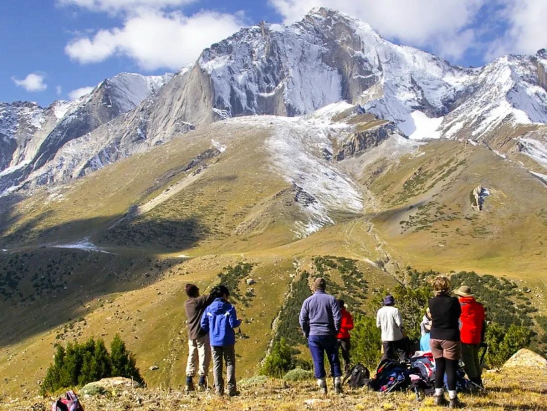
- 2. Tien Shan Mountains
- 3. Ala-Archa National Park
- 4. Top-rated Tours in Kyrgyzstan as Reviewed by Tourists:
- 5. Too-Ashuu Pass
- 6. Sary-Chelek Biosphere Reserve
- 7. Kyrgyz-Ata National Park
- 8. Kulunatin State Reserve
- 9. Jety-Oguz Gorge
- 10. Interesting Excursions from Bishkek:
- 11. Tash-Rabat
- 12. Fergana Valley
- 13. Son-Kul Lake
- 14. Inylchek Glacier
- 15. Cattle Market in Karakol
- 16. Short-term Rentals
- 17. Kyzyl-Tuu Village
- 18. Doves' Watering Place in Chonkurchak
- 19. Arslanbob Forest
- 20. Mountain Serpentine on Arabel Plateau
- 21. Konorchek Canyons
- 22. Mertzbacher Lake
- 23. Zhayma Bazaar in Osh
- 24. Burana Tower
- 25. Sacred Mountain Suleiman-Too (Solomon Mountain)
- 26. Altyn-Arashan Gorge
- 27. Saimaly-Tash Petroglyphs
- 28. Abshir-Ata
- 29. Jailoo Pastures
- 30. Aksu (Lailak) Gorge
- 31. Chychkan Gorge
- 32. Peak Sabakh
- 33. Alay Valley
- 34. Pamir Highway
- 35. Pamir Mountains
- 36. Kozho-Kelen
- 37. Historical Museum
- 38. Petroglyph Museum in Cholpon-Ata
- 39. Map of Attractions in Kyrgyzstan
- 40. Best Hotels in Bishkek for Value

Every tourist should visit this colorful Asian country, as the numerous natural and historical attractions of Kyrgyzstan are truly unique.
The majestic mountain ranges of the Tien Shan and Pamir, canyons and caves, pristine high-altitude lakes, rivers and waterfalls, hot springs, relic forests, and picturesque alpine meadows, as well as rare species of plants and animals, ancient settlements and petroglyphs, old mosques and caravanserais, a distinctive national culture, and culinary diversity.
All of this provides vast opportunities for any type of tourism - active (mountaineering, rock climbing, cycling, hiking, rafting, skiing, etc.), beach activities along the lake shores, wellness retreats in sanatoriums, as well as ethnographic and eco-tourism.
Issyk-Kul

This high-altitude lake is located in a deep depression between the Northern Tien Shan mountain ranges. It is among the largest lakes in the world, covering an area of over 6000 km².
A body of water that never freezes, the mild climate, coniferous air from the mountain forests, and picturesque surroundings have long made the Issyk-Kul region a favorite vacation spot for both residents and visitors of Kyrgyzstan.
The coastline of Issyk-Kul resembles a seaside resort with equipped and wild beaches, sanatoriums, a water park, boat or yacht rides, parachuting, paragliding, surfing, and diving, as well as bars and cafes.
In the vicinity of the lake, you can take excursions into the mountains or go rafting on a mountain river, engage in trekking or mountaineering.
GPS coordinates on Google Maps: 42.45047200250533, 77.16108900839667
Contact Information:
42.45047200250533, 77.16108900839667Tien Shan Mountains

The Tien Shan is one of the highest mountain systems in the world, second only to the Pamir. It stretches over 2,500 km across the territories of Kyrgyzstan, Kazakhstan, Tajikistan, and Uzbekistan. The highest point is Victory Peak (7439 m).
A sprawling chain of foothills and slopes, picturesque valleys and lakes, trails of various configurations and difficulties - all of these have made the Tien Shan mountains an attractive destination for mountaineering, trekking, ski tourism, as well as for summer beach recreation by the lakes, eco- and ethnographic tourism.
The Kyrgyz part of the Tien Shan has a developed infrastructure with trails of varying difficulty, bike paths, and organized excursions to waterfalls and hot springs.
GPS coordinates on Google Maps: 42.04284883633782, 80.00343321210407
Ala-Archa National Park

The park is located on the northern slope of the Kyrgyz Range. Ala-Archa is primarily known for its breathtaking mountain landscapes of the majestic Tien Shan, with an explosion of colors and diverse landscapes. The park's vast territory is home to flora and fauna typical of mountain steppes and forests.
The protected area of Ala-Archa has long been a popular destination for active tourism - mountaineering, rock climbing, trekking, and hiking. The park features numerous trails of varying difficulty levels, and year-round bases with training camps for climbers and rock climbers.
Along the road from the entrance of the reserve to the Ala-Archa base camp, viewing platforms and picnic areas have been equipped.
GPS coordinates on Google Maps: 42.56229291663103, 74.4831287749193
Contact Information:
42.56229291663103, 74.4831287749193Top-rated Tours in Kyrgyzstan as Reviewed by Tourists:
Too-Ashuu Pass

The pass leads from the Chui Valley to southern Kyrgyzstan - into the Osh region. Beyond it lies the high-altitude Suusamyr Valley. Hundreds of years ago, Too-Ashuu was part of the Great Silk Road - caravans of traders passed through here. During the ascent to the pass, one can observe a change of the four seasons - from blooming summer to cold winter.
Too-Ashuu is rightly called the most beautiful road in Kyrgyzstan - a winding mountain serpent road with 'cosmic landscapes,' colossal rocky ridges, and sparse settlements.
At the highest point of the pass (over 3,000 m), there is a tunnel over 2 km long with astonishing acoustics inside.
GPS coordinates on Google Maps: 42.34514853150859, 73.80711581361462
Sary-Chelek Biosphere Reserve

The reserve was established in 1959 to study and preserve the flora and fauna of the Sary-Chelek region. It is located in the gorge of the At-Oinok and Chatkal ranges. Its vast territory of 25,000 hectares is part of the international network of protected areas and is UNESCO protected.
Sary-Chelek Reserve is famous for its natural beauty - ridges with snow-capped peaks, mountain rivers and lakes, colorful meadows, and nut-fruit forests, as well as its diverse fauna.
The main attraction here is the ancient high-altitude lake Sary-Chelek. The water body with crystal clear blue water, picturesque surroundings, and pure air is an ideal place for secluded relaxation. It is a frequent destination for pilgrims, as the lake has been considered sacred since ancient times.
GPS coordinates on Google Maps: 41.66209634767444, 71.92827003949549
Kyrgyz-Ata National Park

The nature park sprawls across the northern slope of the Alai Range at an altitude of 2000-2400 m. It was created to restore and preserve the unique flora in the basin of the Kyrgyz-Ata River - saffron, mountain tulips, and, of course, beautiful juniper forests, which are the park's hallmark.
On the vast protected territory of Kyrgyz-Ata, there are many natural and historical attractions: Sary-Chelek - the third-largest lake in Kyrgyzstan, surrounded by scenic landscapes; deep narrow canyons, colorful gorges and caves; mineral springs; and ancient rock paintings, settlements, and burial mounds.
For eco-tourism enthusiasts, the park offers organized one-day hiking and horseback riding tours.
GPS coordinates on Google Maps: 40.05639736829089, 72.62227956722563
Kulunatin State Reserve

The Kulunatin State Reserve covers the territory between the Fergana and Alai ranges, at the upper part of the Tar River. It was established in 2004 to preserve the biodiversity of the region - over 100 species of animals and birds inhabit the protected mountainous area, along with many medicinal herbs.
The vast protected area includes two separate sections - Kulunata and Tonzoo.
Nature lovers will surely appreciate the diversity and beauty of the surrounding landscapes - forests, alpine and subalpine meadows, canyons, and two picturesque high-altitude lakes with pure water - Kulunata and Ortokol. Exciting horseback tours are organized to the most beautiful places in the reserve.
GPS coordinates on Google Maps: 40.60016954721807, 74.4999625804264
Jety-Oguz Gorge

This is one of the most beautiful places near Issyk-Kul Lake. The Jety-Oguz gorge is surrounded by forest on both sides, while the ridge of red sandstone mountains contrasts beautifully with the vibrant green of the forests.
Eco-tourism enthusiasts are attracted here by the beauty of unspoiled nature - crystal clear lakes, springs and waterfalls, mountain cliffs, and alpine meadows, as well as a diversity of flora and fauna.
Cultural tourists visit the village of Jety-Oguz, which features a mosque, ancient burial grounds, and burial mounds from the 7th-5th centuries BC. You can improve your health at the local balneological resort <<Jety-Oguz>> with therapeutic muds and geothermal springs.
From May to the end of summer, yurt camps are set up for tourists at the Flower Glade (south of the resort), and horseback rides around the area are organized.
GPS coordinates on Google Maps: 42.49358286666334, 78.0984367558374
Interesting Excursions from Bishkek:
Tash-Rabat

The caravanserai Tash-Rabat is located in the Central Tien Shan region. This monument of mountain architecture is located in Tenir-Tuu (the ancient homeland of the Kyrgyz) and was once an important point on the Great Silk Road while crossing the Tien Shan - the structure served not only as a shelter for traders and travelers but also as a fortress against raids from robbers.
A rare example of Central Asian architecture, it impresses with its size - it is the largest stone monument in Central Asia. It consists of a symmetrical rectangular structure with a flat roof, a spherical dome, and very few windows.
To the east is the facade with gates, towers, a portal, and an arch. There are many mysterious passages and hidden exits beneath the structure.
GPS coordinates on Google Maps: 40.8228777166921, 75.28882422807848
Contact Information:
40.8228777166921, 75.28882422807848Fergana Valley

The Fergana Valley is a vast deep basin covering 22,000 km², located in Central Asia between the mountain ranges of the Tien Shan, Gissar, and Alai. The valley is crisscrossed by irrigation canals and numerous rivers and streams flowing from the mountains.
Most settlements in the Fergana Valley have an ancient history of 1.5 to 2,000 years, all of which emerged along the main route of the Great Silk Road.
In the Kyrgyz (southeastern) part of the valley, the historical center of culture, trade, and crafts is the city of Osh. However, the unique eastern charm of the valley is vividly expressed not only in the large tourism centers but also in small, lesser-known yet no less colorful towns and villages.
GPS coordinates on Google Maps: 40.51357189384835, 72.81451525924214
Son-Kul Lake

Son-Kul is the largest natural freshwater body in Kyrgyzstan. This high-altitude lake, surrounded by beautiful meadows, lies on a mountain plain, with the snowy peaks of the Tien Shan looming in the background.
The lake is home to 10 species of fish, along its shores are 66 species of waterfowl and several predators - snow leopards, foxes, red wolves, and others. The shores of Son-Kul are covered in flowers, including rare edelweiss. Higher flower oases transition into picturesque alpine meadows that have been used as summer pastures (dzhailoo) since ancient times.
Son-Kul is a popular eco-tourism destination. Tourists stay in tents or in one of the yurt camps. Nearby attractions include paragliding, horseback riding, and fishing.
GPS coordinates on Google Maps: 41.8357268329569, 75.17681488444993
Contact Information:
41.8357268329569, 75.17681488444993Inylchek Glacier

The Inylchek Glacier is located in the most inaccessible part of the Central Tien Shan - in the Khan-Tengri mountain range. This giant is considered the largest glacier in the Tien Shan - its total glaciated area is over 657 km², and the thickness of the ice cover in some places reaches up to 150-200 m.
For a long time, the mountains surrounding the glacier were hardly accessible and little studied. Today, treks and climbing ascents are made to the glacier from base camps <<South Inylchek>> and <<Karkara>>.
However, such routes require special physical and technical preparation. Tourists can view the glacier from the air during flights organized in the climbing season in July and August.
GPS coordinates on Google Maps: 42.15833060755132, 79.93324692083114
Cattle Market in Karakol

The colorful cattle market in Karakol is one of the largest in the Issyk-Kul region. It emerged in 1869 with the founding of the city of Przhevalsk (modern-day Karakol). This is a great place for lovers of exotic places and for shooting colorful videos and photos. Special guided tours to the market are organized during the summer.
Nomads from all over the region and beyond bring horses, cows, and sheep here to sell every Sunday. It seems as if chaos reigns at the market - clouds of dust rising over the square, loud voices of sellers blending in with the neighing, moos, and bleating of animals.
Yet here, everything is carefully regulated, and the cattle stand in orderly rows along special ties. The market operates from 4 to 10-11 am (until the heat sets in).
Address on Google Maps: Cattle Market, Karakol, Kyrgyzstan.
Contact Information:
Cattle Market, Karakol, Kyrgyzstan.Short-term Rentals
Affordable and cozy accommodation with guaranteed check-in
Kyzyl-Tuu Village

The village is located on the southern shore of Issyk-Kul Lake. Here, around 1800 locals live, most of whom engage in traditional crafts - assembling wooden frames for yurts and making reed mats.
Kyzyl-Tuu is often visited by tourists traveling through Kyrgyzstan. In local workshops, visitors can learn about the craft of yurt-making and even participate in the process of making a traditional Kyrgyz dwelling if they wish.
The Kyzyl-Tuu village hosts an annual festival celebrating the traditions and customs of the Kyrgyz people - Kiyiz Duyno, which attracts thousands of people. Not far from the village is the famous salt lake Kara-Kul, which is often compared to Israel's Dead Sea.
GPS coordinates on Google Maps: 42.44116038386889, 78.2507012912751
Doves' Watering Place in Chonkurchak

This waterfall is one of the most famous and beautiful in Kyrgyzstan. It is located in the picturesque Chon-Kurchak gorge. In summer, flocks of wild doves often come here to drink, which is why locals poetically call the waterfall the <<Doves' Watering Place>>.
The cascading water falls 26 meters from a narrow sheer rock face. In spring, the area around the waterfall turns entirely red due to blooming tulips that reach a height of 17 cm.
The local rocky canyon in the western part of the Tatyra valley is popular among both professional and amateur climbers. However, even unprepared tourists can attempt to climb the sheer cliffs with a guide using safety equipment, which offers stunning views of the surrounding landscapes.
GPS coordinates on Google Maps: 42.6700145440691, 74.63520932250384
Arslanbob Forest

The Arslanbob area is situated in a beautiful gorge on the Babash-Ata ridge, surrounded by red and white cliffs. One of the most notable places here is the Arslanbob valley, known for its relic nut forest, which is considered the largest in the world.
The Arslanbob forest emerged over 50 million years ago. On its vast protected territory, over 130 species of trees and shrubs grow - pear, apple, cherry, pistachio, almond, currant, and others.
However, the main attraction of the local woods is the relic walnut trees. They amaze not only with their age but also with their size - up to 30 m tall and 2 m in diameter. The forest looks particularly picturesque in late spring when the trees and shrubs are in bloom.
GPS coordinates on Google Maps: 41.34068589725769, 72.94314934252861
Contact Information:
41.34068589725769, 72.94314934252861Mountain Serpentine on Arabel Plateau

Arabel Plateau is an ideal place for backcountry fans, breathtaking high-altitude landscapes, and an atmosphere of solitude. It is located at an altitude of about 4000 meters, surrounded by towering mountain ranges.
The Kumtor mine, the largest gold deposit in Central Asia and a leader in Kyrgyzstan's mining industry, is situated on the plateau.
The plateau is accessible via a steep serpentine road with 14 loops offering stunning panoramic views. It is one of the highest roads in Kyrgyzstan, virtually accessible for any vehicle.
The weather on the plateau is always changeable, with strong winds. When it's +30° C on the shore of Issyk-Kul Lake, rain or hail might fall on Arabel Plateau, and snow may even fall at night.
GPS coordinates on Google Maps: 41.83908867545203, 77.81920361493243
Konorchek Canyons

The unusual shapes and shades of the Konorchek canyons are located in the Boom gorge. Some of them have their own names - Skyscraper, Great Canyon, Bobsled. The total length of the ridge is 200 km.
Here lies the extinct volcano Segizkhan Shokny, which is 2.5-3 million years old. The canyons are accessible year-round because the winds make them noticeably warmer in summer and winter, and there is no snow in winter.
After passing through a very narrow gorge that follows the riverbed of a small river, you enter a huge canyon with rocky yellow-orange columns of sandstone rising up to 400 m. Traveling through the canyon feels like walking on the surface of Mars or the Grand Canyon, with the best scenery visible from high cliffs at sunrise or sunset.
GPS coordinates on Google Maps: 42.59655838118676, 75.7818124426933
Contact Information:
42.59655838118676, 75.7818124426933Mertzbacher Lake

This water body was formed in the early to mid-19th century during the aftermath of the Little Ice Age in the Tien Shan. It emerged at the confluence of two main branches of the Inylchek Glacier - the Southern and Northern. From the shores of the lake, there is a breathtaking panorama of the majestic Tien Shan.
The high-altitude Mertzbacher Lake lies between two mountain ranges. It consists of two basins - Lower and Upper lakes, which are at different levels. The distance between them is about 400 m.
The upper lake is always full. The lower lake disappears for 2-3 days in July and August, flowing into the Inylchek River, and then reappears with the melting of the glaciers. The period of violent floods through the glacial dam of the lake is eagerly awaited by extreme rafting enthusiasts.
GPS coordinates on Google Maps: 42.210652620118424, 79.85322459830512
Contact Information:
42.210652620118424, 79.85322459830512Zhayma Bazaar in Osh

The ancient Zhayma Bazaar in Osh is one of the largest and most colorful markets in Central Asia. It has existed for over 2000 years - since the times when one of the branches of the famous Silk Road passed through Osh.
Zhayma Bazaar is a classic example of an Eastern covered market (tima). It stretches for 1 km along the western bank of the Ak-Bura River. Traders come here not only from all corners of Kyrgyzstan but also from China, Uzbekistan, and Tajikistan.
Here you can buy food (seasonal fruits and vegetables, nuts and dried fruits, meat, etc.), fresh pastries and appetizing ready-to-eat meals, as well as household goods, clothing, textiles, souvenirs with national flair, and even livestock.
Address on Google Maps: Zhayma Bazaar, GQRW+57H, Kyrgyzstan, Osh, Kyrgyzstan.
Contact Information:
Zhayma Bazaar, GQRW+57H, Kyrgyzstan, Osh, Kyrgyzstan.Burana Tower

This tower is among the most famous architectural monuments of Kyrgyzstan. It is located on the left bank of the Chu River and is the only fully preserved object of the architectural-historical complex of the 10th-11th centuries, which, in addition to the tower, also includes the ruins of an ancient settlement.
The minaret, 22 meters high and 9 meters in diameter, was built from burnt bricks and juniper beams. The construction consists of a quadrilateral foundation, an octagonal base, and a trunk tapering towards the top, adorned with stripes of brick ornament.
Inside the tower, there is a narrow spiral staircase leading to a viewing platform that offers picturesque views of the surroundings and the entire complex.
Address on Google Maps: 42.74632790714686, 75.25015777546264
Contact Information:
42.74632790714686, 75.25015777546264Sacred Mountain Suleiman-Too (Solomon Mountain)

Suleiman-Too Mountain is a five-headed mountain ridge that stretches over 1 km, rising above the Fergana Valley and the city of Osh.
This unique natural and cultural site associated with ancient traditions and cult practices is popular among tourists and pilgrims. Moreover, it is the only natural landmark in Kyrgyzstan included in the UNESCO World Heritage List.
On all the peaks of the mountain, complexes of sacred stones and ancient petroglyphs thousands of years old have been found. On one peak, there is the mausoleum of Babur Shah, and at the foot of the mountain ridge, there are the Ravat-Abdullakhan Mosque from the 16th century, the mausoleum of Asaf ibn Burhiya from the 18th century, and medieval baths. Seven caves are located on the slopes of the mountain - two of which are home to museums.
GPS coordinates on Google Maps: 40.53025691047919, 72.78506312888265
Altyn-Arashan Gorge

The high-altitude Altyn-Arashan gorge is located near the city of Karakol. It is not easy to reach - part of the road runs along the edge of a cliff, and in spring, the road is often blocked by rocks.
Access to Altyn-Arashan can be made by all-terrain vehicles, horses, or on foot. In the picturesque gorge, tourists stop in guest houses, yurts, or tents.
The resort area located in the picturesque gorge has been known since Soviet times for its mineral hot springs with healing properties.
However, people come here not only to heal but also to enjoy the beauty of the surrounding nature - glaciers, lakes, and waterfalls, relic spruce forests, as well as to savor the peaceful and quiet atmosphere of tranquility.
GPS coordinates on Google Maps: 42.381580796282854, 78.60670018247804
Contact Information:
42.381580796282854, 78.60670018247804Saimaly-Tash Petroglyphs

Located on the northeastern slope of the Fergana range is the Saimaly-Tash National Park. Here, in remote mountains at an altitude of 3-4.5 km, the largest collection of ancient rock drawings in the world has been discovered.
The petroglyph gallery in the Saimaly-Tash area includes over 20,000 drawings from different historical epochs - from the Bronze and Iron Ages to antiquity. The oldest petroglyphs date back to the 3rd to early 2nd millennium BC.
The main themes of the rock art are depictions of animals, hunting scenes, chariot journeys, scenes of daily life, and ritual dances. The Saimaly-Tash petroglyphs are a UNESCO World Heritage treasure. They allow a glimpse into ancient times, as seen through the eyes of our distant ancestors.
GPS coordinates on Google Maps: 41.18069120106628, 73.81399773251115
Contact Information:
41.18069120106628, 73.81399773251115Abshir-Ata

In the Abshir-Ata National Park, located at an altitude of 1500-2500 m, there lies a picturesque gorge of the Abshir-Sai River - one of the most visited natural attractions by tourists and pilgrims in the Osh region.
Flowing through the valley, the Abshir-Sai River forms a beautiful canyon, famous for its caves, a unique waterfall, and healing springs. The Abshir-Ata waterfall, with a height of 15 meters, cascades powerfully from a sheer rock face. The clean mineral water, rich in calcium and magnesium, is considered sacred and healing by locals.
Among the other attractions in the Abshir-Sai valley are the namesake lake, healing springs - Kotur Bulak, Koz Bulak and Beshik Bulagy, as well as ancient rock paintings.
GPS coordinates on Google Maps: 39.96619727423507, 72.34539242551675
Contact Information:
39.96619727423507, 72.34539242551675Jailoo Pastures

Each year, around 3.9 million hectares of mountainous and foothill areas in Kyrgyzstan are occupied by jailoo - summer high-altitude pastures. Jailoo tourism is a new and already popular direction that has emerged in Kyrgyzstan. The most well-known jailoo tours in the republic are around Son-Kul Lake, in the Semyonov Gorge, as well as Jailoo Salar-Saz, Zhaman Echk, Kilemche.
During the tour, travelers are taken to the mountains to the pastures, offering them a chance to temporarily forsake modern comforts and immerse themselves in the traditional life and culture of the nomadic Kyrgyz - sleeping in shepherd's yurts, washing in icy water from the mountain river, roasting a lamb, and drinking kumis.
You can also take hiking and horseback rides through the picturesque mountain landscapes, enjoy the clean mountain air, and admire the night sky filled with billions of bright stars.
GPS coordinates on Google Maps: 41.917934610011166, 75.05141194689085
Contact Information:
Son-Kul Lake Salar-Saz Zhaman Echk Kilemche 41.917934610011166, 75.05141194689085Aksu (Lailak) Gorge

Surrounding the famous Issyk-Kul Lake are several picturesque mountain ranges. One of them is Aksu (Lailak) Gorge. Its peaks form a rocky barrier that curves around the glacier. A string of five-thousanders rises from west to east, the highest and most challenging of which is Peak Aksu (5355 m).
The canyon walls rise 300 m, and its bottom is washed by the waters of the river of the same name. Around are high mountain landscapes - sharp rocky mountains, sparkling snowfields on slopes, cold air, and the astounding silence of nature.
Climbers, rock climbers, and mountain tourists often visit here, drawn by the countless unique routes in the gorge area.
GPS coordinates on Google Maps: 39.73908908563975, 69.99252997454884
Contact Information:
39.73908908563975, 69.99252997454884Chychkan Gorge

Chychkan Gorge is a marvelous natural attraction in the northern part of the Jalal-Abad region of Kyrgyzstan. It is located approximately at the 250-kilometer mark of the Bishkek-Osh highway.
Chychkan Gorge boasts everything that high-altitude Kyrgyz nature is famous for - mountain ridges, murmuring mountain rivers and pristine streams, small lakes, magnificent waterfalls, spruce and pine forests, birch groves, juniper, barberry thickets, and fields of red mountain poppy, pure air, and picturesque landscapes.
All of this attracts numerous eco-tourists who dream of enjoying the silence and harmony of pristine nature. Chychkan Gorge is also popular among mountain tourism lovers - skiers, climbers, white-water rafters, and hikers, as well as cyclists and avid fishermen.
GPS coordinates on Google Maps: 42.00856946396611, 72.86051453560053
Contact Information:
42.00856946396611, 72.86051453560053Peak Sabakh
Peak Sabakh, rising to 5200 meters, is one of the peaks of the Turkestan ridge in the Pamir-Alai mountain system. The nature of Pamir-Alai is remarkable. Here, the vibrant colors of valleys and foothills shift to the modest palette of rocks, snow, and ice. The high mountain peaks are sharply outlined, and the fresh air is laden with the dense aroma of juniper forests.
Ascents to Peak Sabakh typically begin in a small mountain village of Uzgarish, from where the steep rocky slopes carved by gorges are clearly visible. Just a couple of kilometers up separates summer from winter.
Peak Sabakh is a resilient and sturdy rock, conquering which is not easy. But for those who succeed, the stunning views from the summit will be a lifelong memory - the true 'roof of the world'!
GPS coordinates on Google Maps: 39.57282163887498, 69.89805453967524
Alay Valley

The Alay Valley is a picturesque part of the Pamir-Alai mountain system in southern Kyrgyzstan. It is a tectonic depression between two mountain ranges - the Alay and Zaalai ranges. In ancient times, the valley was entirely covered by a gigantic glacier. Today, powerful sparkling glaciers cover the peaks of the Zaalai range.
The high-altitude Alay Valley captivates with its landscapes of multicolored rocks and picturesque canyons. An unusual reddish-brown river, Kyzyl-su, flows through here, contrasting beautifully with the green alpine meadows, the white snowy peaks, and the piercing blue sky.
Once the Great Silk Road passed through the Alay Valley, and today the Pamir Highway (the section from Osh to Khorog via the Sary-Tash pass) runs through here.
GPS coordinates on Google Maps: 39.597821523828415, 72.85305970692741
Contact Information:
39.597821523828415, 72.85305970692741Pamir Highway

The Pamir Highway is a high-altitude road stretching over 700 km, connecting Osh (Kyrgyzstan) with Dushanbe and Khorog (Tajikistan). In the highest regions and offshoots from the main road, the road is unpaved and therefore not used in winter due to the risk of landslides.
The route of the Pamir Highway in Kyrgyzstan passes through several main points:
- Osh City in the Fergana Valley;
- Taldyk Pass over the Alay Range;
- Gulcha Village and the Gulcha River Valley;
- Sary-Tash Village (Alay Valley);
- Kyzyl-Art Pass over the Zaalai Range.
Contact Information:
Osh City Taldyk Pass Gulcha Village Sary-Tash Village Kyzyl-Art Pass 40.538709583271775, 72.85463158667892Pamir Mountains

The greatest mountains of the Pamirs, lost in the depths of Asia, separate Tajikistan, Kyrgyzstan, China, Pakistan, and Afghanistan. They appear different everywhere but are invariably beautiful and mysterious.
To the northwest, high mountain ranges of the Pamir-Alai mountain system join the Pamirs, part of which is the Turkestan Range. Its northern slopes in central and eastern areas are a training ground for climbers of all levels.
Tourists and outdoor enthusiasts also explore the Lailak (Aksu) and Karavshin gorges. The Zaalai Range, the northern outpost of the Pamirs, stretches across Kyrgyzstan from west to east.
Routes here are organized for every taste - from active family recreation with elements of ethno- and eco-tourism in camps and yurts to treks for experienced climbers.
GPS coordinates on Google Maps: 39.500225882944456, 70.99873467217301
Contact Information:
39.500225882944456, 70.99873467217301Kozho-Kelen

The Kozho-Kelen natural and ethnographic complex is a mountainous region straddling the Djiptyk River in a picturesque valley at the foot of the Alay Range of the Pamirs. Kozho-Kelen offers a variety of hiking and horseback routes, as well as great opportunities for rock climbing and ethnographic tourism.
The main local attraction is the unusual ocher-hued rock formations. Over thousands of years, the reddish rocks, shaped by wind and water, have transformed into fairy-tale mazes of canyons and whimsical compositions.
Among other natural beauties of the complex are the 50 m high Kozho-Kelen waterfall, the sacred Blue Grotto with an underground lake, as well as the exotic village of Kozho-Kelen, whose inhabitants have preserved the lifestyle, traditions, and customs of their distant nomadic ancestors.
GPS coordinates on Google Maps: 39.954234002084185, 72.94922844071793
Contact Information:
39.954234002084185, 72.94922844071793Historical Museum

The National Historical Museum of Kyrgyzstan, founded in 1925, is considered one of the largest in Central Asia. Its unique collections tell the rich history and the distinct culture, daily life, and traditions of the Kyrgyz nation throughout its existence - from ancient times to the present day.
The museum's collections include over 80,000 items, of which about 40,000 are on permanent exhibition.
Among the exhibits are archaeological and ethnographic collections - weapons and everyday items from the Bronze Age, jewelry made from precious metals, ancient petroglyphs, stone sculptures, bronze and ceramic artifacts, tools, and various other artifacts, as well as national costumes and musical instruments, horse tackle, and wool, leather, and felt products.
Address on Google Maps: National Historical Museum of the Kyrgyz Republic, VJH3+3GC, Chuy Ave, Bishkek, Kyrgyzstan. Website: https://historymuseum.kg/
Petroglyph Museum in Cholpon-Ata

This open-air museum is located near Issyk-Kul Lake, at the edge of the resort town of Cholpon-Ata. You can reach the exhibition area with unique ancient petroglyphs either via a tour group or independently (on foot or by car).
The petroglyph museum in Cholpon-Ata is also known as the Stone Garden, as it consists of an area covered with numerous boulders of various sizes and shapes. Stones ranging from 30 cm to 3 m in diameter are covered with rock paintings dating back to the period from 2000 BC to the 7th century AD.
The well-preserved drawings depict realistic scenes of wars, hunting, feasts, and daily life of ancient peoples, as well as animals - mainly deer and snow leopards.
GPS coordinates on Google Maps: 42.65787927116672, 77.05680662482436
Contact Information:
42.65787927116672, 77.05680662482436