- 1. Old Town
- 2. Budva Promenade
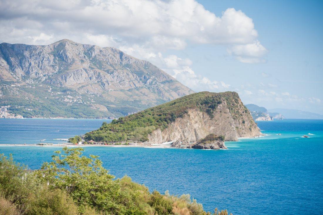
- 3. Sveti Stefan Island
- 4. The Best Excursions in Montenegro as Reviewed by Tourists:
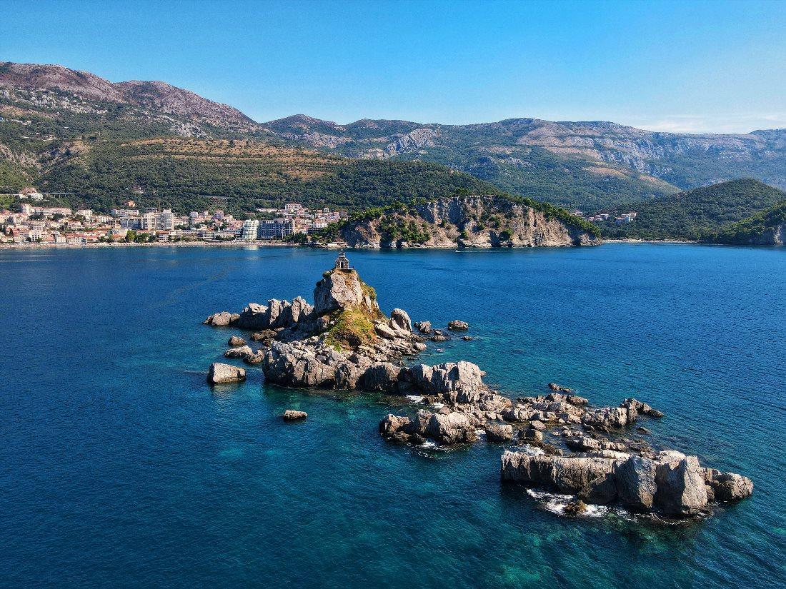
- 5. St. Nicholas Island
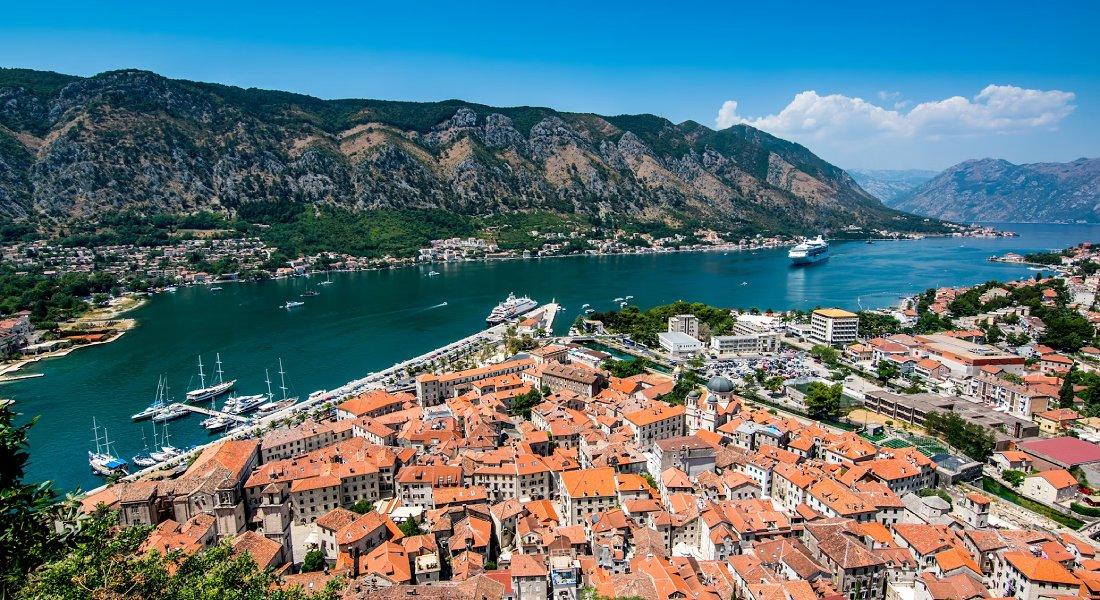
- 6. Boka Kotorska Bay (Bay of Kotor)
- 7. Fortress
- 8. Kotor Old Town
- 9. St. Luke's Church
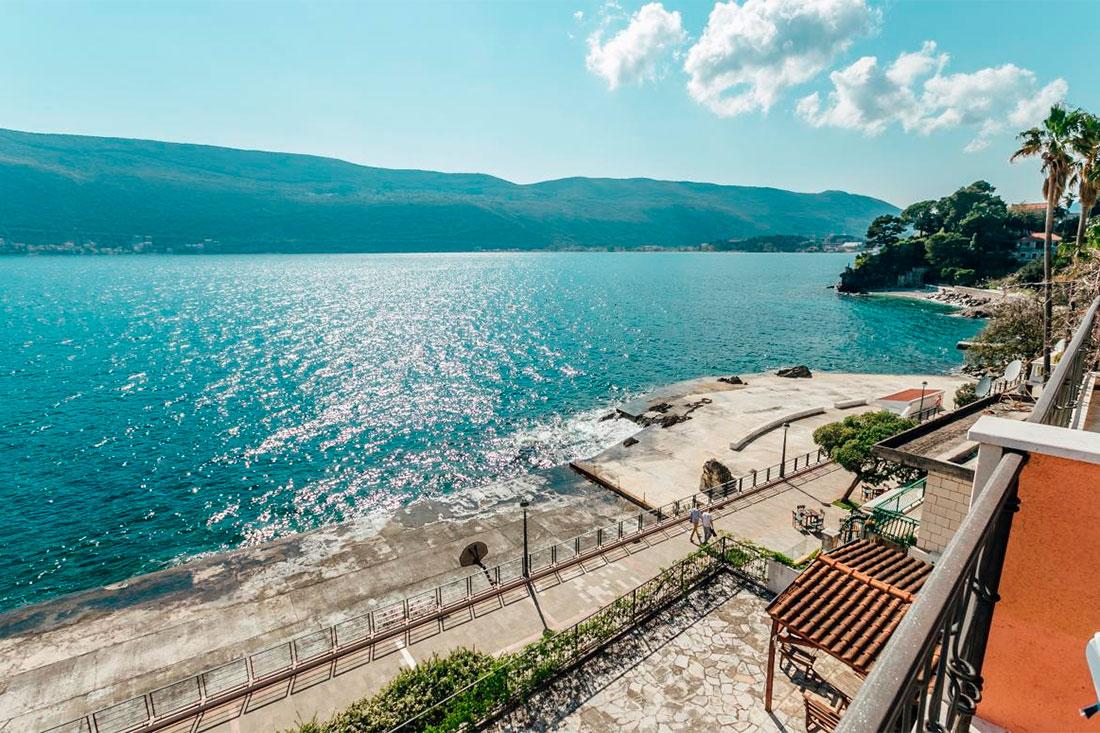
- 10. Promenade
- 11. Vrmac Fortress
- 12. Our Lady of the Rocks
- 13. Mamula Island Fortress
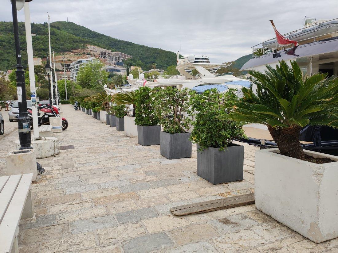
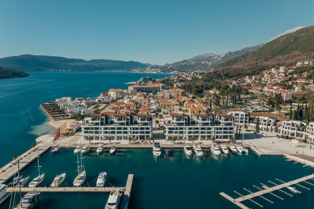
- 14. Porto Montenegro
- 15. Medieval Bucha Palace
- 16. Gornja Lastva Village
- 17. St. Mark's Island or Stradioti Island
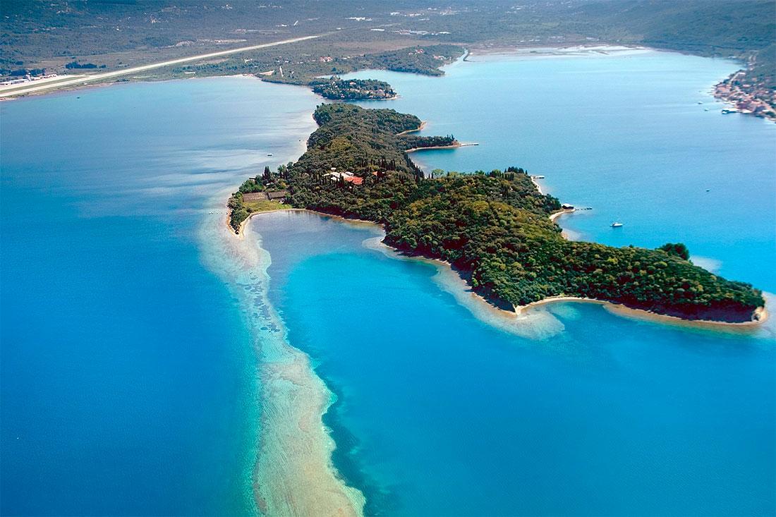
- 18. Island of Flowers
- 19. Old Town
- 20. Kanli Kula
- 21. Herceg Novi Promenade
- 22. Porto Novi
- 23. Blue Cave
- 24. Old Town
- 25. Velika Plaža
- 26. Ada Bojana
- 27. St. Nicholas Church
- 28. Health Trail
- 29. Kastello Fortress
- 30. Cat and Resurrection Islands
- 31. Millennium Bridge
- 32. Ruins of the Ancient City of Duklja
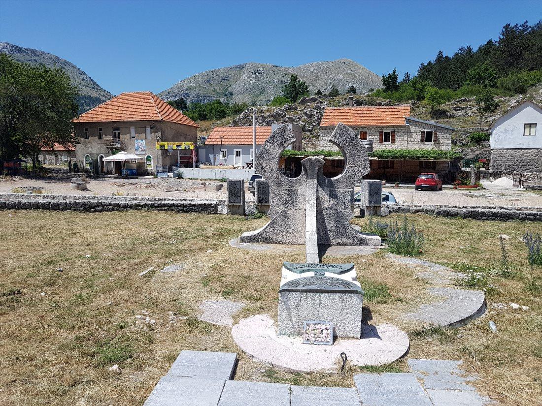
- 33. Lovćen
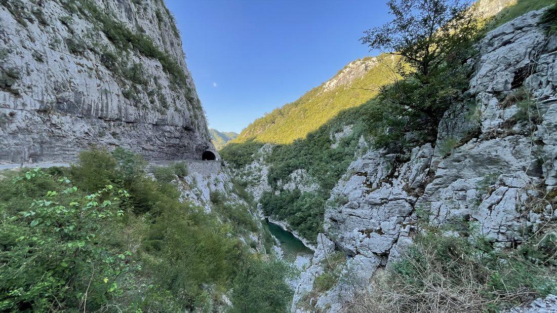
- 34. Tara River Canyon
- 35. Moraca River Canyon
- 36. Đurđevića Bridge
- 37. Durmitor National Park
- 38. Biogradska Gora National Park
- 39. Prokletije National Park
- 40. Piva River Canyon
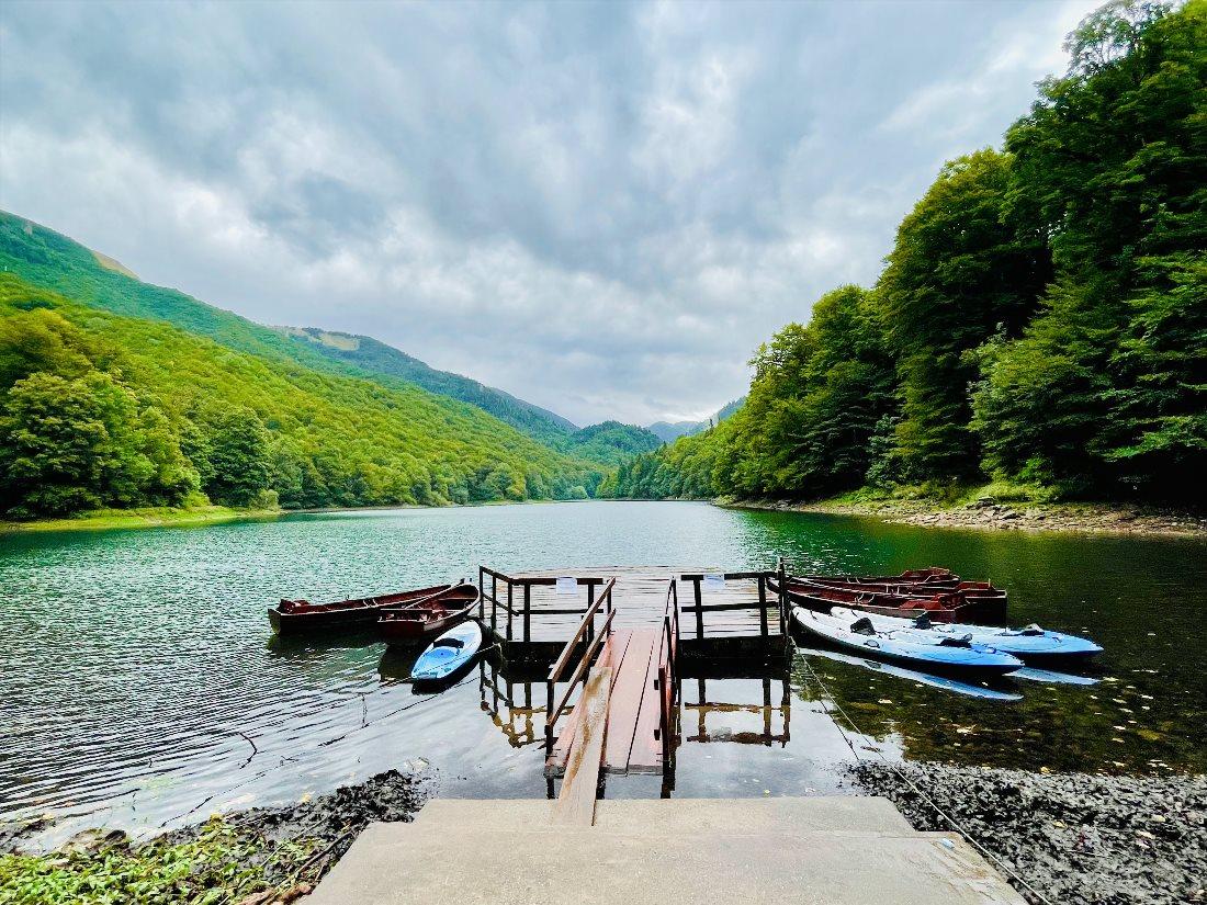
- 41. Skadar Lake
- 42. The Village of Njeguši
- 43. Old Town
- 44. Žabljak
- 45. Fort Rose
- 46. Ostrog Monastery
- 47. Cetinje Monastery
- 48. Moraca Monastery
- 49. Piva Lake
- 50. Virpazar
- 51. The town of Prčanj
- 52. Map of Attractions in Montenegro
- 53. The Best Hotels in Montenegro for Value
In southern Europe, along the Adriatic Sea, lies a small but incredibly beautiful country, Montenegro. You can drive through this country in a day, but to visit all the picturesque corners and explore most of the interesting places, you will need much more time.
Let's embark on this exciting journey together - we certainly know which sights in Montenegro are worth visiting.
Old Town
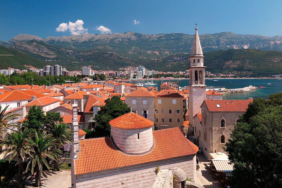
Budva is a city on the Adriatic Sea and the center of the municipality of the same name. It is 2500 years old, making it one of the oldest settlements on the Adriatic coast. The coastal area around the city, known as the Budva Riviera, is the center of Montenegrin tourism.
This place is famous for its well-preserved medieval fortress city, located on a rocky peninsula. Although the city has been inhabited since Roman times, most of the existing city walls and buildings were built during the Venetian rule.
Often, Budva's Old Town is the first thing tourists want to see in Montenegro. The defensive fortifications of Budva are typical for medieval fortress cities of the Adriatic - complete with towers, embrasures, city gates, and a citadel.
The Old Town was heavily damaged during the earthquake of 1979. Repairs and reconstruction took eight years, and today, traces of the damage are barely noticeable. The narrow cobblestone streets of the Old Town feature residential houses with red tiled roofs, four churches, museums, restaurants, cafes, pubs, and shops.
Contact Information:
Old Town, Budva, Montenegro.Budva Promenade
Along the coastline of Budva, there is a well-maintained promenade. This street is two kilometers long, and it takes about 30 minutes to walk in one direction. The promenade ends with a pedestrian tunnel leading to the neighboring village of Bečići. This passage is a sort of art space filled with graffiti and murals.
The scenic views of the sea and beaches make walking along the promenade especially pleasant. From here, there is a magnificent view of Budva's Old Town and numerous yachts moored at the docks. Benches and ice cream stalls line the promenade, and this street hosts bars, restaurants, cafes, and nightclubs.
Contact Information:
42.28495009416279, 18.84717828546442Sveti Stefan Island
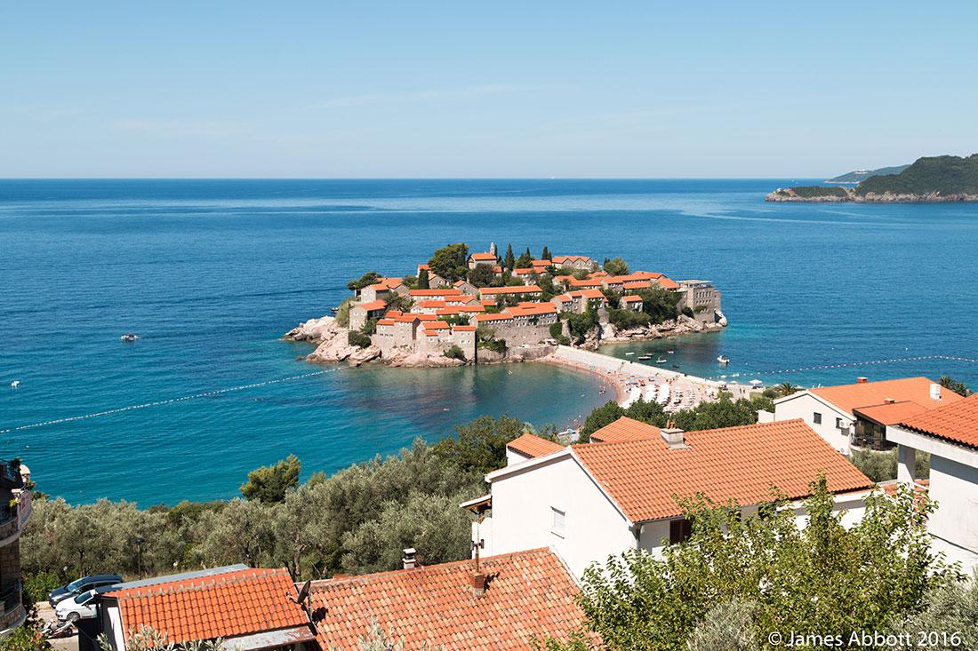
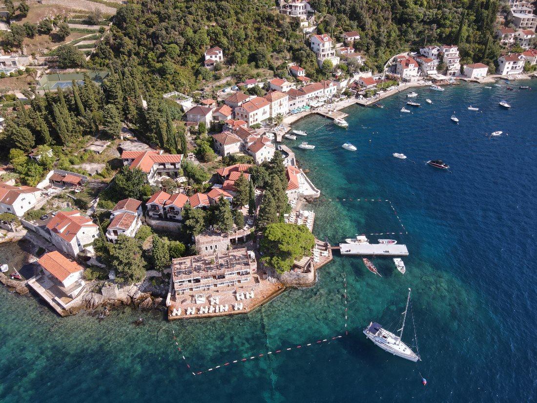
The picturesque resort village of Sveti Stefan is part of the municipality of Budva and is located on the island of the same name. It is set on the Adriatic Sea and is connected to the mainland by a narrow artificial isthmus with a pedestrian bridge.
The site, six kilometers from Budva, where the island is located, is known as the Budva Riviera. Today, the island of Sveti Stefan features a 5-star resort - one of the most expensive in Montenegro.
The island is built with 15th-century stone buildings with red tile roofs that form a beautiful ensemble. Access to Sveti Stefan is available only to guests of the hotel located there, restaurant visitors, and tourists on guided excursions. Since only two tours are allowed per day, it's advisable to book in advance. Two beaches are located near the isthmus - one for hotel guests and one for the general public.
Contact Information:
Peninsula Sveti Stefan, Sveti Stefan, Montenegro.The Best Excursions in Montenegro as Reviewed by Tourists:
St. Nicholas Island
Visible from anywhere in Budva is St. Nicholas Island, located in the Adriatic Sea. It is the largest island in Montenegro, measuring 2 kilometers in length and covering 36 hectares. The terrain is rocky, and its highest point rises 121 meters above sea level. During the peak season, ferries regularly depart from Budva to the island.
St. Nicholas Island is a popular destination for day trips during the summer months. The island is uninhabited, but there is plenty of greenery and beaches. Three large beaches total 840 meters in length, while multiple small beaches around the island can only be reached by boat. The rocky shores are surrounded by bays with clear water perfect for snorkeling. There is a walking trail laid out across the island.
Contact Information:
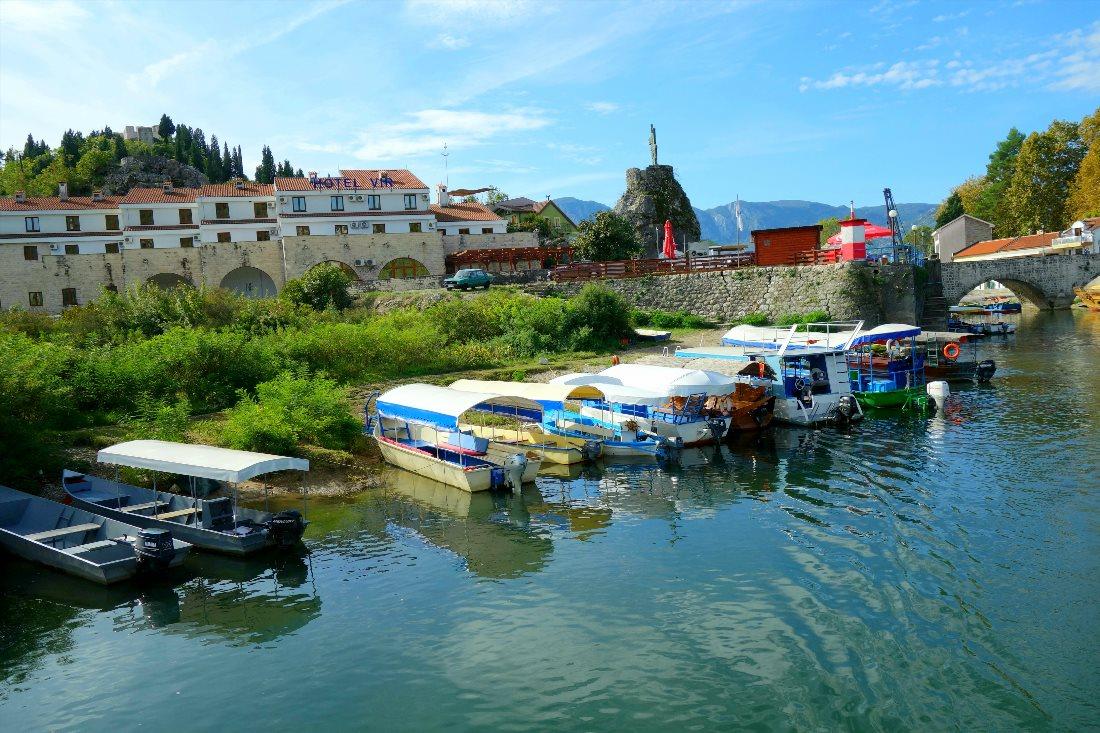
42.26637065476831, 18.85152839128321Boka Kotorska Bay (Bay of Kotor)
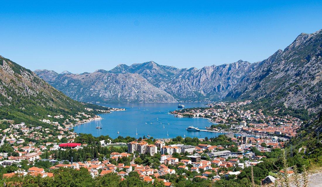
Boka Kotorska Bay is one of the most interesting natural places in Montenegro. It is located on the border with Croatia, extending 28 kilometers inland, and in its structure represents a typical fjord.
Most tourist guides describe Boka Kotorska Bay as "the southernmost fjord in Europe." The inner part of the bay, along with its surroundings, the fortifications of Kotor, and the Old Town of Kotor were designated a UNESCO World Heritage Site in 1979.
Boka Kotorska Bay is not only the largest bay in the Adriatic Sea, but also one of the most beautiful bays in the world. The bay's depth is impressive, ranging from 20 to 60 meters, allowing giant cruise ships to enter the bay all the way to the city of Kotor.
Excursions around Boka Kotorska Bay are considered among the most interesting in Montenegro. While cruising the bay on a boat, tourists can admire fantastic landscapes, see seven islands, and charming villages and small towns that stretch along the shores.
Contact Information:
42.431272748467826, 18.654848754058296Fortress
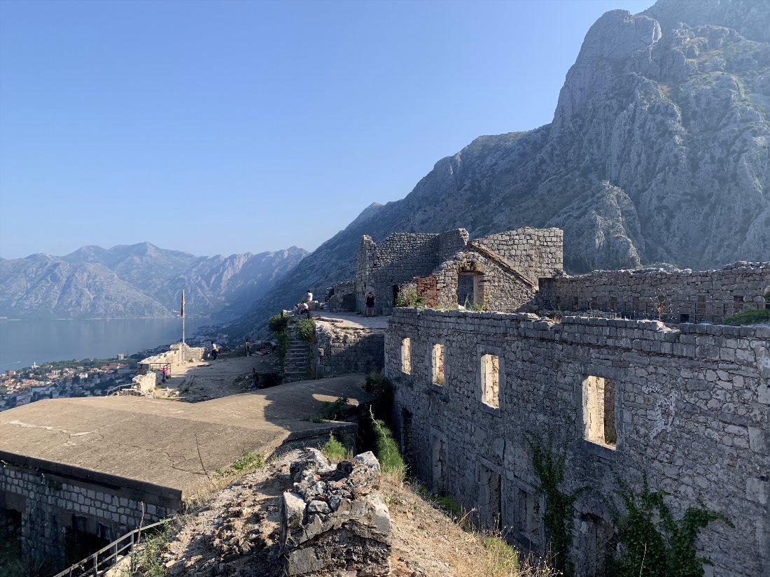
Kotor Fortress is a complex historical fortification system that protected the medieval city of Kotor. It included walls, towers, gates, bastions, auxiliary buildings, and structures built from the 9th to the 19th century.
The fortress wall is 4.5 kilometers long, 2 to 16 meters thick, and 20 meters high. Together with the Old Town and its natural surroundings, the fortifications of Kotor were included in the UNESCO World Heritage List in 1979.
Since the Venetians built most of the current structures, the fortress is one of the most significant examples of defensive Venetian military architecture.
It is located above the city, on top of a 260-meter hill, from where there is a beautiful view of the Old Town of Kotor and Boka Kotorska Bay. A walk through the fortress is suitable for those who enjoy active leisure, as scaling the hill requires climbing 1350 steps.
Contact Information:
42.42195128000664, 18.77454714213355Kotor Old Town
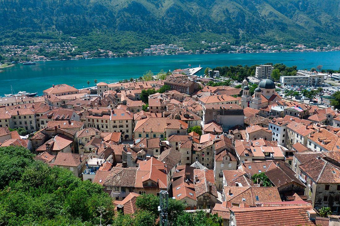
The most well-known part of Kotor is the stunning Old Town. It is considered one of the best-preserved medieval city centers on the Adriatic that have been included in the UNESCO World Heritage List.
From 1420 to 1797, the city of Kotor and its surroundings were under the rule of the Venetian Republic, so Venetian influence remains dominant in the city's architecture.
The Old Town is small and can be walked through in two hours, but it's worth spending more time to appreciate every corner of this place. All of Old Kotor is a pedestrian zone. There are many narrow paved streets and stone stairs, ancient houses, and churches here.
Palaces of princes and other noble families were built in the 14th-18th centuries, while Catholic and Orthodox churches were constructed between the 12th and 18th centuries. In the historical quarters, there is a town hall with a clock tower and a maritime museum.
Contact Information:
42.42505153000235, 18.769805597195756St. Luke's Church
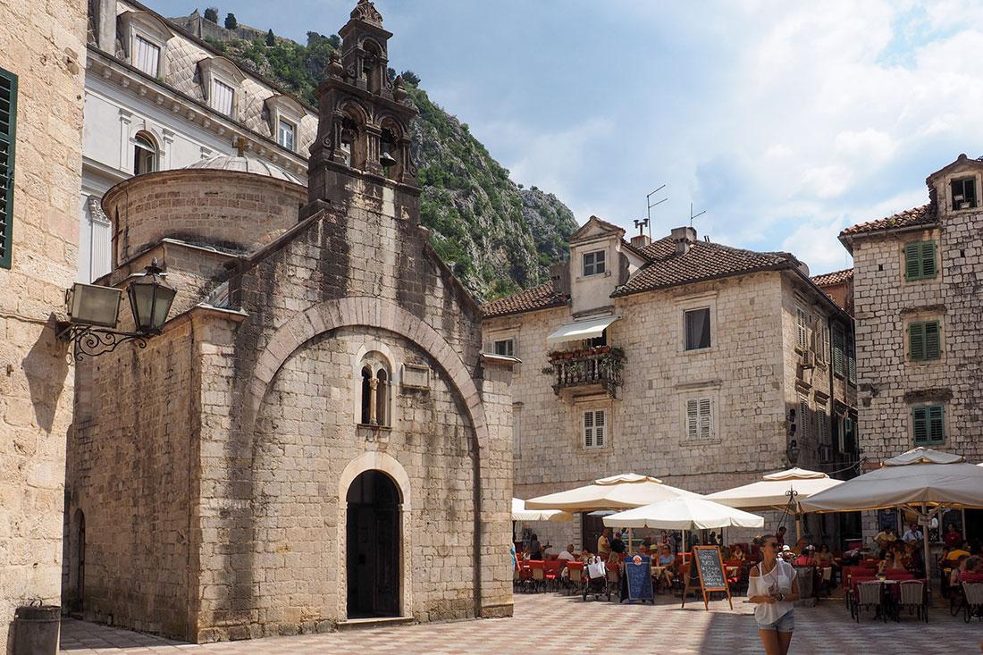
This church was built in 1195 by Mauro Kacafrang, as indicated by the inscription on the western facade. The modest building exhibits features of both Roman and Byzantine architecture. Since its founding, the church has been Catholic.
From 1657 to 1812, Catholic and Orthodox altars stood side by side, with representatives of each faith alternating in conducting services. The temple was then handed over to the Serbian Orthodox Church.
St. Luke's Church is a beautiful example of early Christian church design in Kotor. This temple is the only building in the city that didn't suffer significant damage during the devastating earthquake of 1979.
Today, fragments of 12th-century frescoes remain, as well as two beautifully decorated iconostases: one from the 17th century in the main church and another from the 18th century in the chapel of St. Spiridon, another saint revered by both faiths.
Contact Information:
St. Luke's Church, Trg Sv. Luke, Kotor 85330, Montenegro.Promenade
One of the popular spots in Kotor is the promenade, which allows for a walk along the bay. It starts near the Old Town and continues through the suburb of Kotor, the neighboring village of Dobrota.
Along its length, this street is laid with paving stones and is bordered by a small metal fence along the bay. Its modern appearance dates back to 1979 when it was restored after the earthquake.
You can walk the promenade from beginning to end in about an hour and a half. Along the way, incredible views of the mountains, bay, and pier with yachts will unfold before you.
You will encounter old, well-maintained houses with red tiled roofs, small bars and cafes featuring local cuisine. In the southern part of the promenade, a monument to seafarers is installed.
Contact Information:
42.425598080467324, 18.76761098446224Vrmac Fortress
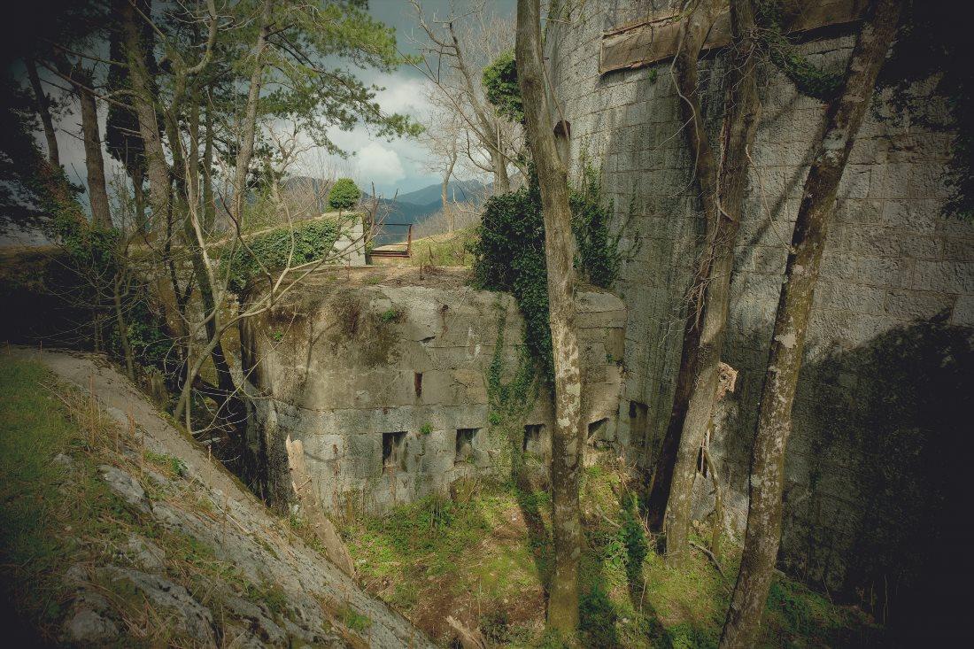
Between Tivat and Kotor, there is another fortress - Vrmac. This former fortification of the Austro-Hungarian Empire, established in 1860, is located at the southern end of the Vrmac ridge. Construction of the fort took place from 1894 to 1897. During WWI, the fortress underwent heavy bombing, and after WWII it was abandoned.
Today, Vrmac Fortress is one of the best-preserved Austro-Hungarian defenses in the Bay of Kotor area. The fort remains in a state of disrepair. This location, not very popular among most tourists, attracts those who enjoy wandering through abandoned structures. It can be visited, but caution is advised due to the presence of holes in the floors.
Contact Information:
42.42104137771947, 18.749328019041755Our Lady of the Rocks
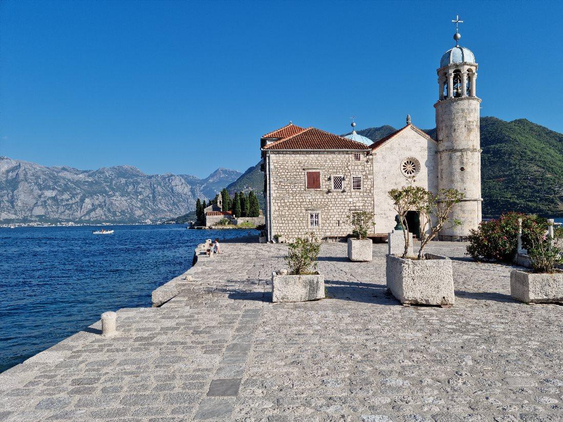
Among all the islands of the Adriatic, there is the only man-made island - Our Lady of the Rocks. Its name translates to "Our Lady on the Rock." This island was artificially created starting in 1452 around the rock on which a miraculous icon of the Virgin Mary was discovered.
For nearly two centuries, locals filled the area around the rock with stones and old ships. Sailors from passing ships also threw stones into the water. This way, a plateau was formed, and in 1630, an Orthodox church was built in the center. The church's current appearance resulted from reconstruction after the earthquake in 1667.
The church, built in the Byzantine style, reaches 11 meters in height. The temple is small but very cozy. Its walls are adorned with 68 paintings, crafted over ten years by Tripe Kokolja - a famous Baroque artist. Here, visitors can also see 2500 "votive" plates made of gold and silver.
The second floor of the church has been converted into a museum dedicated to the lives of sailors and their families. The custom of throwing stones at the island has persisted to this day and has turned into the festival of Fašinada, celebrated annually on July 22.
Contact Information:
42.486577166878874, 18.68887407747234Mamula Island Fortress
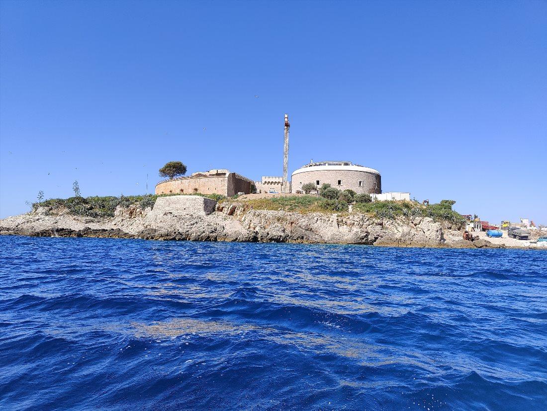
This small uninhabited island in the Adriatic Sea is also known as Lastavica. It has a nearly round shape with a diameter of 200 meters. In 1853, a fort was built here, occupying 90% of the island's area.
It was constructed under the guidance of Austro-Hungarian General Lazar Mamula, after whom the fortress is named. The island is not far from Jaz Beach, where tickets for excursions can be purchased.
Fort Mamula was designed to prevent a potential enemy from entering Boka Kotorska Bay. During WWII, a concentration camp was established within the fortress.
As such, the Montenegrin government's plan to convert the island into an exclusive resort, approved in 2016, was met with mixed reactions. Today, Mamula is a stop on many excursion programs around Boka Kotorska Bay.
Contact Information:
42.39530520722145, 18.558175983410795Porto Montenegro
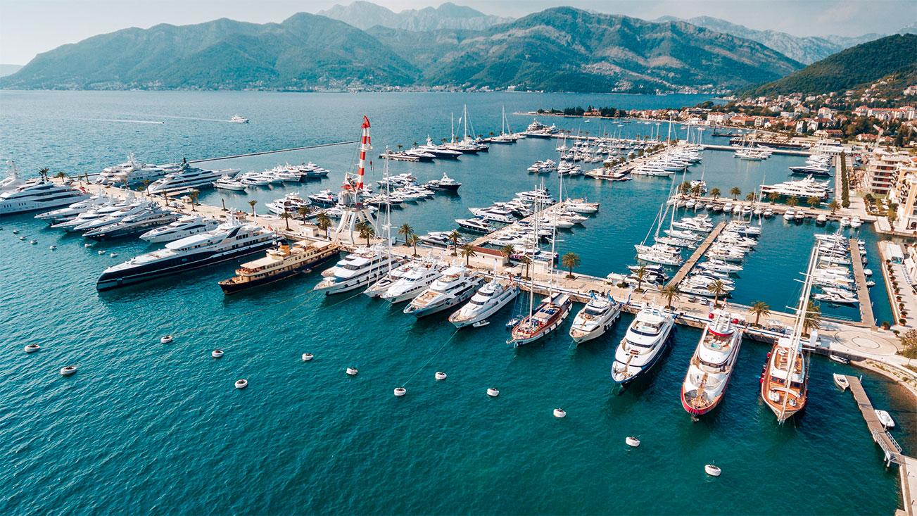
The proximity of the airport and yacht marina, the presence of all necessary conditions for yachting, and the beauty of Boka Kotorska Bay made Tivat an ideal location for a marina.
The realization of a luxury-level comprehensive project began in 2006. Porto Montenegro was conceived as a small town with developed infrastructure, where everything necessary for the living and recreation of yacht owners and enthusiasts is available.
Porto Montenegro has no analogs in the Adriatic, and only a few similar projects exist in Europe. The marina has over 600 yacht berths, including for 150 mega-yachts of up to 150 meters in length.
The complex includes elite apartments, fashionable boutiques, an attractive promenade, a maritime museum, restaurants, hotels, bars, entertainment venues, and spaces for relaxation filled with palm trees and exotic plants. The area is open to visitors, and tourists do not miss the chance to take pictures among the luxurious yachts.
Contact Information:
Porto Montenegro, Obala bb, Tivat, Montenegro.Medieval Bucha Palace
One of Tivat's main attractions is the Bucha Palace. The summer residence of the wealthy Montenegrin Bucha family was built in the 17th century. Adjacent to the small house is the family church with a chapel. All buildings are made of stone and surrounded by a stone wall. The complex is complemented by a gallery and a garden.
The palace is located in the center of Tivat. Today, this architectural monument is a cultural center of the city. There is an ethnographic museum and an art gallery hosting exhibitions and literary evenings. A small stage is set up in the garden for summer theatrical performances.
Contact Information:
Bucha Palace, Njegoševa, Tivat, Montenegro.Gornja Lastva Village
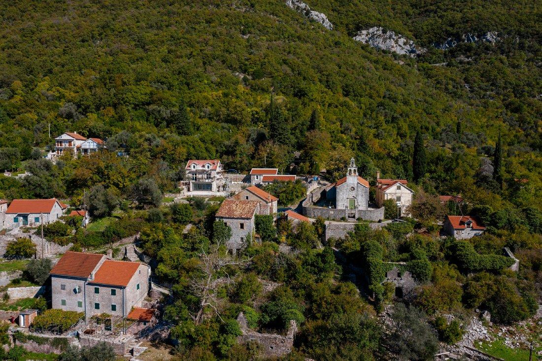
This small village appeared in the vicinity of Tivat during the Middle Ages. The first mention of the settlement dates back to the 16th century. Gornja Lastva is located on a hillside, 300 meters above sea level.
Several dozen stone buildings in the village showcase a distinct yet simple architecture. To reach the village, one can take a taxi or walk - the uphill trek takes about 1.5 hours.
Gornja Lastva has preserved the features of its original architecture, making it appealing to tourists. Here, visitors can see old residential houses and a church, stone benches, and ancient water reservoirs.
However, this charming rural corner, quiet and colorful, is now almost abandoned. Only a few houses remain inhabited, while most of the village consists of the ruins of stone buildings covered in ivy.
Contact Information:
Gornja Lastva, Montenegro.St. Mark's Island or Stradioti Island
Historically, this island is known as Stradioti Island. In translation, "stradiotis" means "soldier," and according to legend, it was once used by Venetian soldiers as a camp.
By the end of the 16th century, military units were disbanded, and the island was named after St. Mark - the patron saint of Venice and protector of Venetian people.
The island, covered in dense forests, is located near Tivat in Boka Kotorska Bay, level with the Flowers Island. In 1962, a tourist settlement was built here with 500 straw huts in a Polynesian (Tahitian) style, without water supply and electricity.
This resort was a highlight of the area and enjoyed popularity. Today, much of the settlement is abandoned, giving the island a mysterious atmosphere.
Contact Information:
St. Mark's Island, Stradioti, Montenegro.Island of Flowers
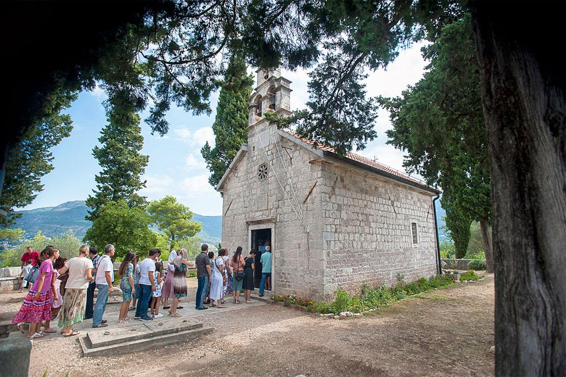
St. Michael's Island, Miholjska Prevlaka, or the Island of Flowers is located close to the shore and nearly becomes a peninsula during low tides. It measures 300 meters in length and 200 meters in width.
The island houses the Monastery of Archangel Michael. Founded in the early 13th century by St. Sava, it was the medieval residence of the Montenegrin metropolis. During socialist Yugoslavia, a closed resort operated on the island for military personnel.
Today, around 100 people live on the Island of Flowers. The Monastery of Archangel Michael remains here to this day and is currently undergoing slow restoration. Nearby stands a small Church of the Holy Trinity, built in the 19th century.
Once, the Island of Flowers was lush with greenery and blooming plants. Today, remnants of this former splendor are preserved on the beach of the island, where tourists come to relax. The Island of Flowers can also be visited with a tour group.
Contact Information:
Miholjska Prevlaka, Montenegro.Old Town
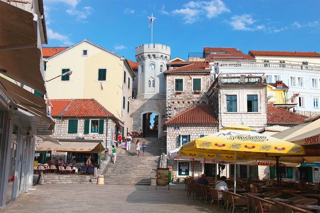
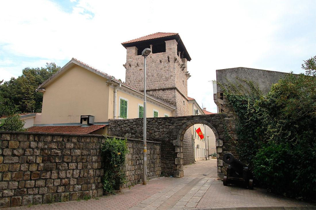
The Old Town of Herceg Novi is over 640 years old. It was founded in 1382 by the Bosnian King Tvrtko I, who intended to turn it into a successful trading port. As salt was an important commodity at that time, Herceg Novi became a competitor to Dubrovnik in the salt trade.
The town is situated at the foot of Mount Orjen and has a hilly terrain. There are many steep paths and stairs here, so it's often called "the city of a thousand steps."
The Old Town is surrounded by walls built between the 14th and 19th centuries. The most significant monuments within the city include the Forte Mare Castle (14th century), Kanli Kula (15th century), the Clock Tower (19th century), and an eclectic-style Orthodox Church (built at the turn of the 19th and 20th centuries).
All of these structures preserve the spirit of the era in which they were built. The Old Town, with its buildings of various sizes, styles, and construction periods, appears very unusual. However, this eclecticism looks stunning against the backdrop of beautiful maritime landscapes.
Contact Information:
Old Town, Herceg Novi, Montenegro.Kanli Kula
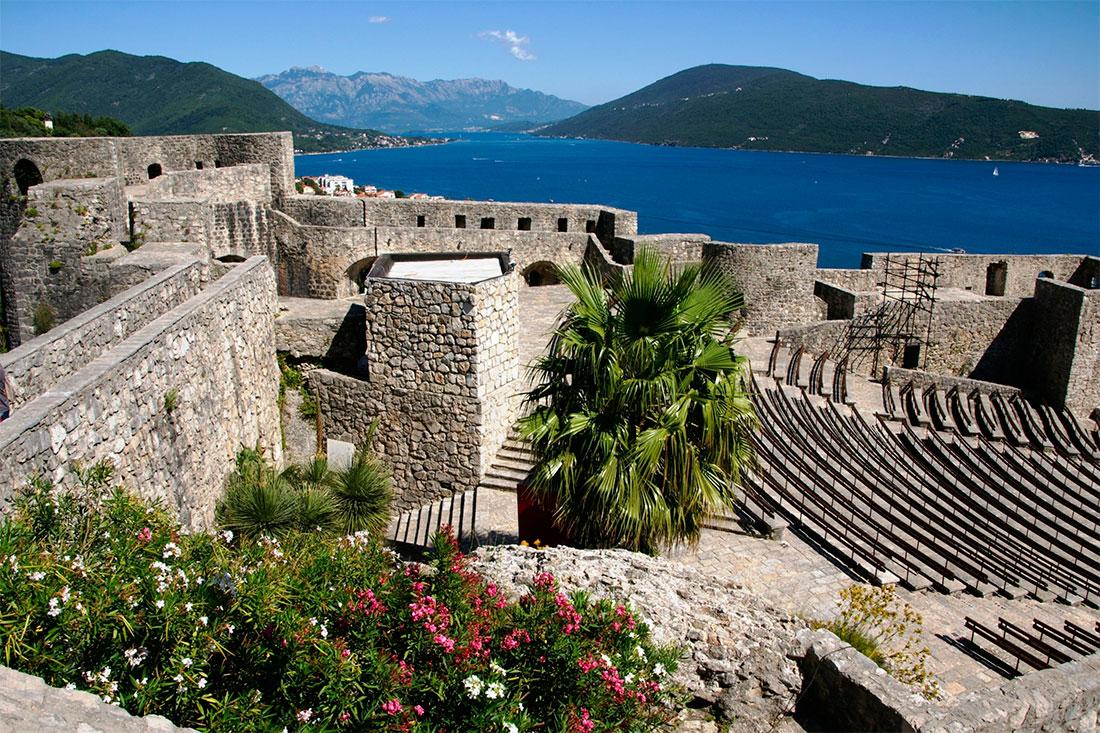
The Kanli Kula tower was built by the Turks in 1539. Its name is of Turkish origin and translates to "blood tower." This landmark is located in the upper part of the Old Town.
During the Ottoman Empire, there was a prison here, from which, according to legend, no prisoner ever escaped. Currently, the entrance to the tower is only accessible from early May to late September.
The inner courtyard of the Kanli Kula tower is so large that in 1966 it was converted into an open-air amphitheater. This space can accommodate over 1000 spectators.
Today, many cultural events and festivals take place here, including the Herceg Novi Film Festival, the Summer Festival of Guitar Art, and the Montenegrin Opera Festival.
Contact Information:
Kanli Kula Fortress, Herceg Novi, Montenegro.Herceg Novi Promenade
Most of the numerous stairs in Herceg Novi lead to the city promenade. This long street stretches 7 kilometers along the coast - from the coastal park of Igalo in the west to the town of Meljine in the east.
The attractive promenade is a hub of events and activities, especially during the summer months. In the sections of Igalo and Herceg Novi, numerous restaurants, bars, shops, and beaches are located. However, as one progresses eastward, this lively street gradually becomes quieter.
Contact Information:
Pet Danica Walkway, Herceg Novi, Montenegro.Porto Novi
A luxury resort called Porto Novi was built several years ago about seven kilometers from the city of Herceg Novi. This idyllic Mediterranean-style location is surrounded by the wild beauty of Boka Kotorska Bay. The resort offers everything from shops and galleries to sports clubs and wellness centers.
It features luxurious homes, a world-class marina with moored yachts, elite rental apartments and villas.
In Porto Novi, you can find: a five-star hotel with exquisite cuisine and a world-famous spa, a private white sand beach, endless outdoor pools, and beautifully landscaped gardens.
Blue Cave
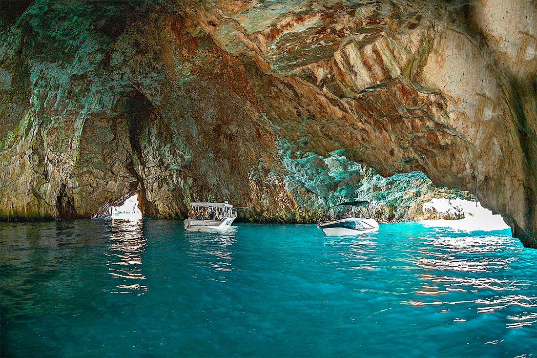
The Blue Cave is a popular natural attraction located 9.5 kilometers from the city of Herceg Novi, on the Lustica Peninsula. The area of the cave is 300 square meters.
Entrance to it is only possible from the sea, and two entrances are located in a vertical cliff. Small boats can pass through these openings, which are 3-4 meters high and 15 meters wide, for boat tours.
However, traversing the cave in a boat is only possible in calm weather. If there are waves on the sea, they will prevent this.
The cave gets its name from the amazing color of the water. Sunlight that enters refracts in the crystal-clear sea water, painting it an unforgettable azure color and creating a fantastic blue glow.
Locals say this enchanting grotto is at its most beautiful at noon. During tours, each tour operator gives guests 10-15 minutes to swim in the waters of the Blue Cave.
Contact Information:
Blue Cave Montenegro.Old Town
Old Town Ulcinj is one of the oldest architectural complexes on the Adriatic coast. It is located on a high rocky outcrop surrounded by a massive stone fortress wall. The Old Town is believed to have been built by the Greeks in the late 5th - early 4th century BC, although it was destroyed during an earthquake in the 5th century.
The current appearance of the Old Town was shaped when the Romans rebuilt it in the 6th century. The fortress underwent multiple restorations and modifications by the Byzantines, Serbs, Venetians, and Ottomans.
The old town contains the cultural and historical heritage of Ulcinj. Its eastern part features the Kalaja fortress, in the northern section of which lies the fortress gate - the only entrance to the city from land. Today, there is an ethnographic museum here.
The dominant structure of the fortress and the entire Old Town is the Balšić Tower, which now houses an art gallery. Near the tower, there is the former Catholic Cathedral of the Virgin Mary, which contains an archaeological museum.
Contact Information:
41.92456016395561, 19.201961897916203Velika Plaža
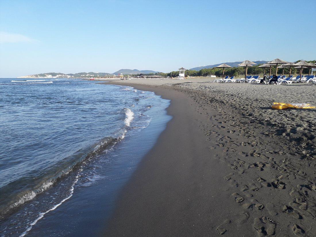
Velika Plaža is the name of the beach in the municipality of Ulcinj, extending from the Milena port to the Bojana River. This beach is 12 kilometers long, making it the longest in Montenegro and one of the longest in Europe. Unlike most Montenegrin beaches dominated by pebbles, the shore here is sandy, and the entrance to the water is gradual and comfortable.
Today, Velika Plaža is the best place for kitesurfing along the entire Adriatic coast. The shallow waters, warm temperatures, and strong winds blowing almost every day in the summer make it ideal for safe learning.
Several kitesurfing schools are located along the beach. There are cafes, attractions, and camping spots available. Nature lovers are drawn to sections of the beach where there is nothing but sea and sand.
Contact Information:
41.894332036279415, 19.290129756529907Ada Bojana
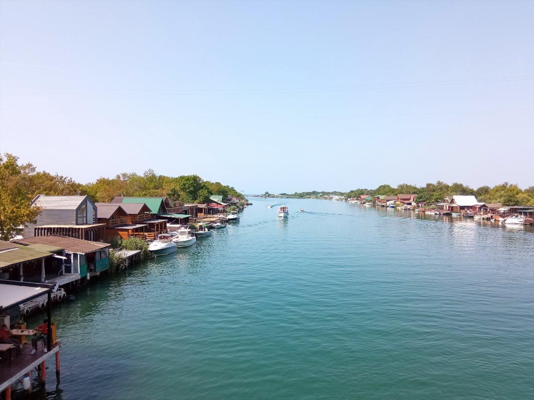
Ada Bojana is an island formed by the delta of the Bojana River. It is located at the southernmost tip of Montenegro, on the border with Albania. The island has a triangular shape and an area of 4.8 square kilometers.
It is washed on two sides by the Bojana River and on the southwest by the waters of the Adriatic Sea. Ada Bojana features camping areas, seafood restaurants, and two cafes. Small cabins with varying levels of comfort have been converted into hotel accommodations.
The beach stretches 3 kilometers with width varying from 50 to 150 meters. 20% of the island is occupied by a regular beach and 80% by a nudist beach, the largest in Europe.
There are also designated hotels for nudists. Kayaks and pedalos can be rented on the island. There are stables, and kitesurfing schools operate here.
Contact Information:
41.86199898995956, 19.360957040808575St. Nicholas Church
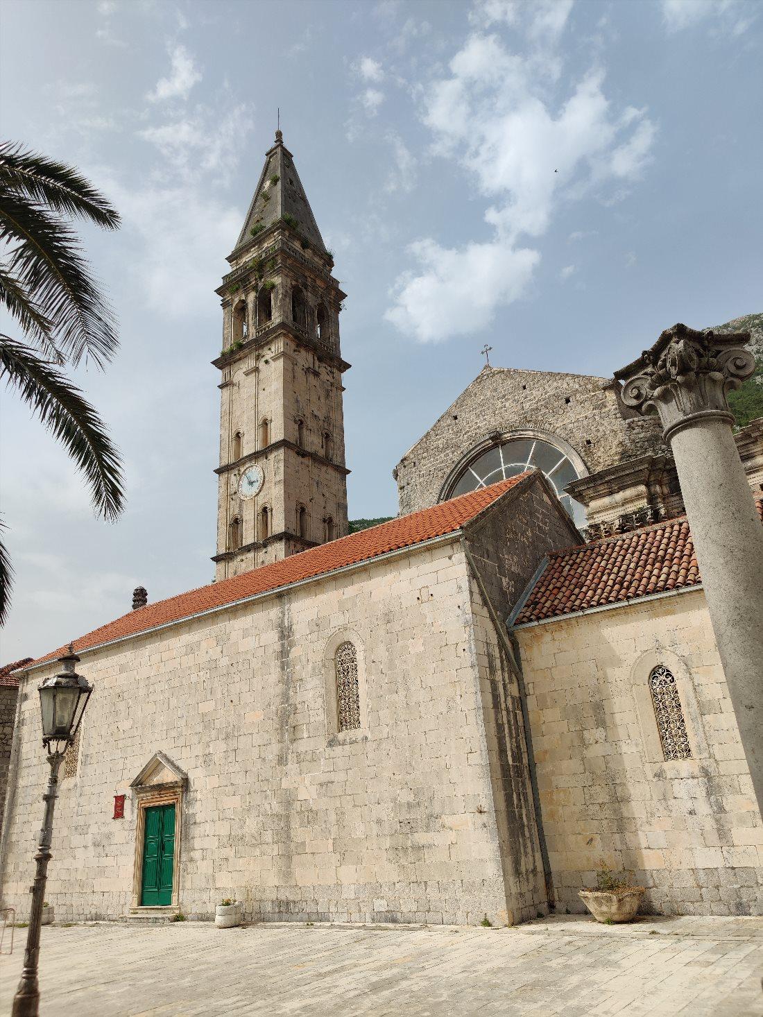
This church was built in 1616. Later, in the 18th century, the city authorities decided to convert the parish church into a cathedral. A project for a new majestic building was drafted, and construction began but was never completed.
Even now, St. Nicholas Church consists of two structures from different eras and architectural styles. Today, worship services are conducted in the old church, while the new part of the cathedral has been transformed into a museum.
St. Nicholas Church is an architectural landmark of Perast, thanks to its 55-meter bell tower, which was built in 1691. Tourists can enjoy magnificent views from the top of the tower - the observation deck is at the same level as the church bells.
The museum houses a rich collection of artwork and religious artifacts. This includes ancient drawings and manuscripts, valuable icons, handmade embroidery, and luxurious church vestments.
Contact Information:
42.486183952995496, 18.6986562675767Health Trail

At the exit from Petrovac, there is a small walking area on a hillside. It is called the "Health Trail" and is about a kilometer long. This path runs along the seashore, passes through a pine forest and two tunnels. Tall trees create dappled shade, making it easy to breathe even in strong heat.
The Health Trail is one of the best places for walking. The picturesque views of Petrovac's coastline, islets, and beach will make your walk unforgettable. From the trail, you can also see the magnificent Kastello Fortress. Numerous benches along the path allow tourists to rest while enjoying the fantastic natural views.
Contact Information:
42.20685, 18.93141Kastello Fortress
In the 16th century, the Venetians built a fortress above the pier in Petrovac, after which the entire place was named Castel Lastva. Here, a permanent Venetian garrison was established.
A sanitary facility used as a quarantine place for sailors was also built here. Today, the fort and the hospital are recognizable parts of the landscape of this area.
Kastello Fortress is the symbol of Petrovac, which can be seen on many tourist postcards. It is located on a rocky cliff surrounded by the Adriatic Sea.
From the observation deck, there is a magnificent view of the sea, promenade, and beach. The fortress features a museum that houses a collection of mosaics, frescoes, paintings, and other ancient artifacts.
Contact Information:
42.2052367431755, 18.937109546925058Cat and Resurrection Islands
Opposite Petrovac's city beach, a kilometer off the shore, are two small rocky islands. These are Big Katich and Small Katich, which is better known as Resurrection Island.
According to legend, sailors were able to find refuge on this island during a fierce storm. In gratitude, a small church was built at the very top of the rock. It is still believed that this island protects sailors.
Tourists love to swim to Resurrection Island to climb to the church and ring the bell. It is said that this brings health, happiness, and good luck. Katich Island can also be visited by kayak or tourist boat. Both islands are popular spots for photographers.
Contact Information:
42.195964765134505, 18.935599055142204Millennium Bridge
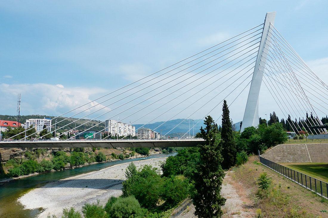
The Millennium Bridge over the Morača River in Podgorica connects the Old Town with the new districts. The bridge was opened to traffic on July 13, 2005, on Montenegro's National Day. The structure is 173 meters long and features a roadway as well as pedestrian paths in each direction.
This cable-stayed bridge quickly became one of the most notable landmarks in Montenegro's capital. Its pylon rises 57 meters above the road's surface and is visible from a distance. Twelve cables support the roadway while another 24 are attached to counterweights. They create an impressive image of the structure, which is now impossible to imagine the city's appearance without. In the evening and at night, an impressive illumination is turned on at the bridge.
Contact Information:
Millennium Bridge, Podgorica, Montenegro.Ruins of the Ancient City of Duklja
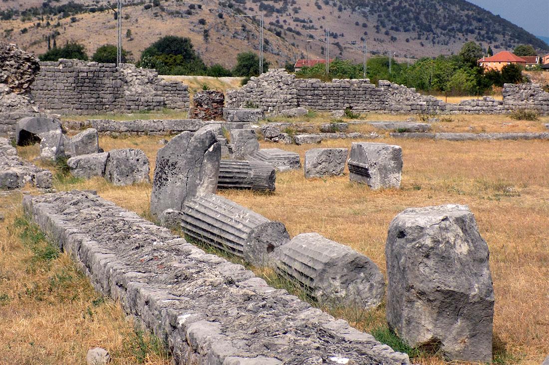
The ruins of Duklja (Doclea) are an interesting archaeological monument located near Podgorica. The remains have significant historical value as they provide insight into the ancient Roman city that once thrived in this region.
This was an important trading center of the Roman Empire, established around 2000 years ago. Throughout its history, the city faced various calamities (invasions and earthquakes) that eventually led to its decline.
Echoes of its past glory can still be seen in the ruins that have survived to this day. While walking through this site, visitors will see the remnants of ancient structures, including a basilica, triumphal arch, several temples, a palace, towers, streets, and villas.
Columns of perfect shape, stone carvings, and bas-reliefs still evoke admiration. During excavations, jewelry, pottery, and other artifacts were discovered. These findings are now housed in the City Museum of Podgorica.
Contact Information:
Duklja, Podgorica, Montenegro.Lovćen
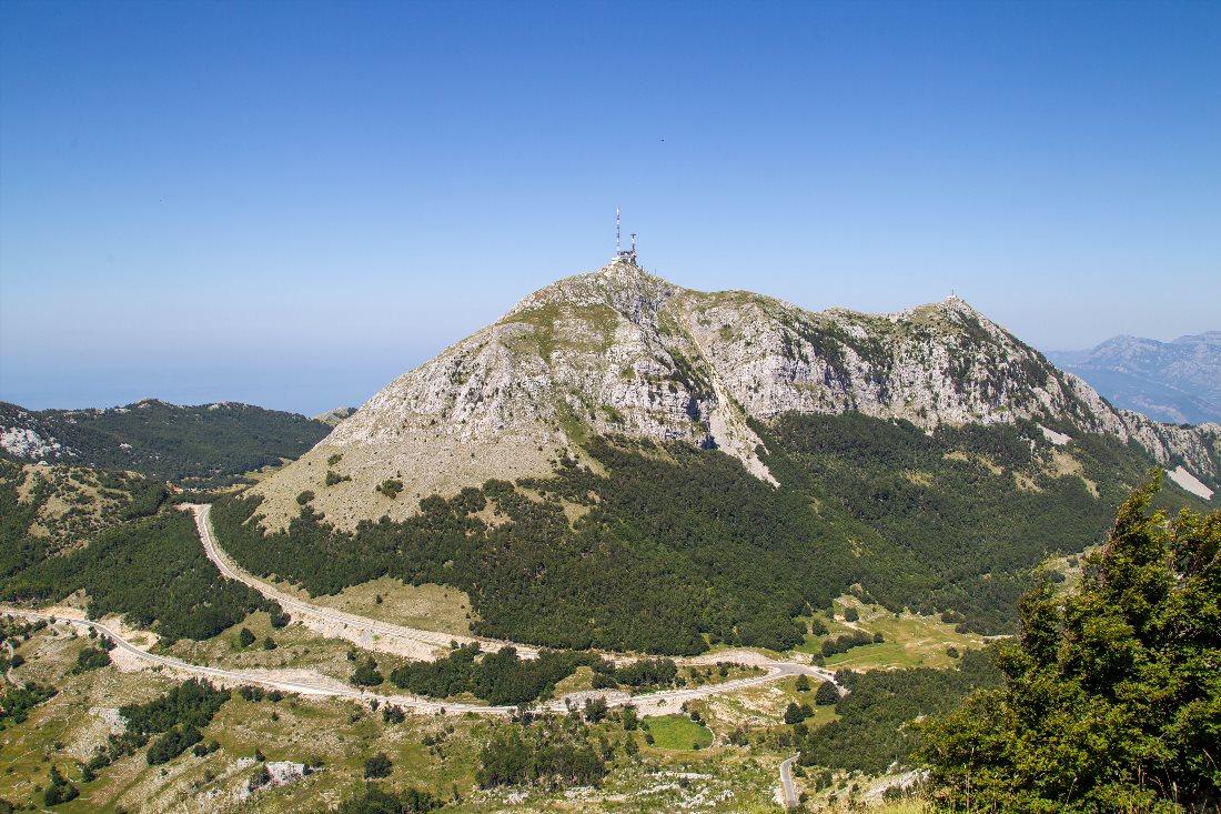
Mount Lovćen has two peaks - Štirnovik (1749 meters) and Jezerski vrh (1657 meters). The mountain has an unusual appearance - its rocky slopes are crisscrossed with numerous fissures and deep depressions.
It is said that the heart of Montenegro beats here. This is why Peter II Petrović Njegoš, the metropolitan and ruler of Montenegro (prince) from 1830 to 1851, bequeathed to be buried in this area. The mausoleum of Peter II Petrović Njegoš is located at the top of Jezerski vrh.
Initially, the reformer and statesman was buried in a chapel. From 1960 to 1975, a stone mausoleum was built in its place, featuring marble statues, a mosaic floor, and a ceiling adorned with gold. From the mausoleum, a narrow paved path runs along the ridge of the mountain, leading to the lookout point at the top of Štirnovik.
It is said that on a clear day, one can see a significant portion of the country from here. In 1952, Lovćen National Park was created, which includes the highest part of the mountain range and its surroundings.
Contact Information:
42.399475080427926, 18.818803025786263Tara River Canyon
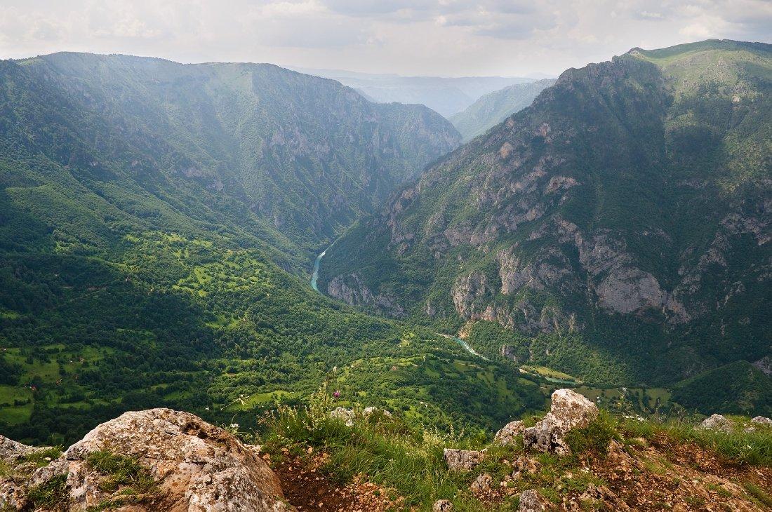
The Tara River has carved a deep gorge through the rocky landscape, which today is considered one of the most beautiful natural attractions in the country.
Between 1937 and 1940, the Đurđevića Bridge was constructed over the canyon. For a long time, it was the only road connecting the north and south of Montenegro. The Tara River Canyon is part of Durmitor National Park, which has been recognized as a UNESCO World Heritage Site.
The canyon impresses with its size. It stretches 80 kilometers, and its depth reaches 1300 meters, making it the second deepest in Europe. The rocky slopes of the canyon are covered with green vegetation, while a rushing stream flows at its bottom - an unmissable sight. Rafting on the Tara River is one of the popular tourist activities in the country.
Contact Information:
43.12849, 19.31031Moraca River Canyon
The Moraca River Canyon is located in the municipalities of Podgorica and Kolasin. Part of this 100-kilometer river flows through a valley where it meets Skadar Lake. In its upper reaches, the Moraca is a fast-flowing mountain river that has carved its way through the rocks, forming a picturesque canyon.
The Moraca River flows shallow and narrow, but the magnificent canyon it has cut through the rocks reaches depths of 1000 meters in places. Along the edge of this narrow 30-kilometer gorge, a highway is built with many tunnels. There are several viewpoints that offer breathtaking views of the canyon's wild beauty.
Contact Information:
42.55511373974197, 19.33625475597899Đurđevića Bridge
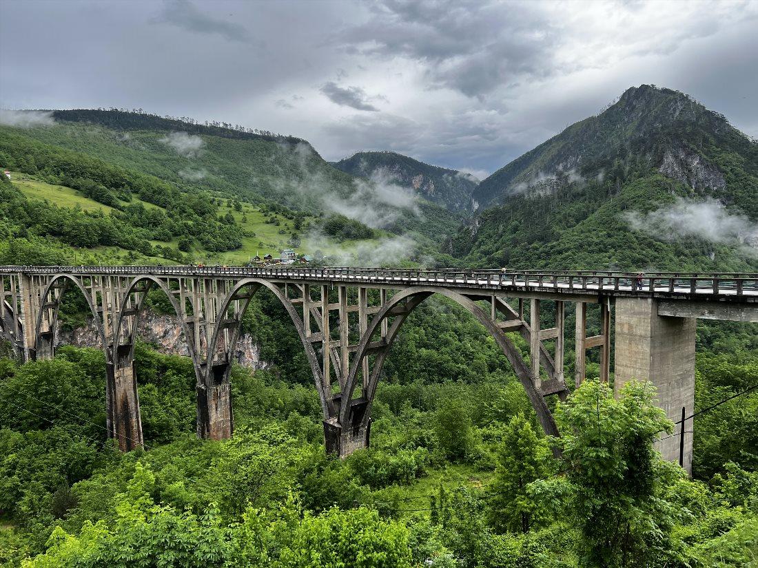
Đurđevića Bridge is a concrete arch bridge over the Tara River located in northern Montenegro. The precise location of the bridge is between the villages of Budčevica and Trešnjevo. This structure was designed by engineer Mijat Trojanović and built between 1937 and 1940 by the Andonović company from Belgrade.
The five-arch bridge spans 365 meters over the gorge of the Tara River. The largest span measures 116 meters. The roadway is situated 172 meters above the water level.
When completed, this was the largest automobile concrete arch bridge in Europe. Today, it is considered one of the most beautiful in Montenegro and invariably attracts tourists with cameras.
Contact Information:
43.150205040186115, 19.294877256066467Durmitor National Park
Durmitor National Park was established in 1952. Its territory includes the eponymous mountain range, the canyons of several rivers, and the upper part of the Komarnica plateau.
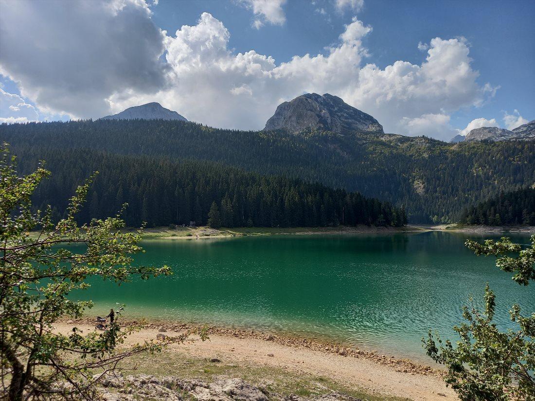
The massif has 48 peaks over 2000 meters high. The park's "jewels" are 18 glacial lakes scattered throughout the mountain and the plateau of Jezerska Površ. These beautiful lakes significantly enhance the beauty of the mountain landscapes, earning them the name "mountain eyes."
In 1980, the national park was included in the UNESCO World Heritage List. The untouched nature of the Durmitor massif, with its mountain peaks, coniferous forests filled with centuries-old 45-meter pines, crystal-clear mountain lakes, and the deep rocky canyon of the Tara River, leaves unforgettable impressions.
Visitors to the park can stroll along walking trails, rent bicycles, take horseback rides, or take a boat ride on the rivers and lakes. In winter, skiing and snowboarding are popular activities here.
Biogradska Gora National Park
When the city of Kolasin was freed from Turkish rule in 1878, the residents of Morača and Rovči presented part of the forest to King Nikola I Petrović-Njegoš of Montenegro.
By the king's decree, the forest was protected, making it the oldest protected area in Montenegro. In 1952, this area was declared a national park. Its area is 54 square kilometers, making it the northeasternmost of Montenegro's five national parks.
Today, Biogradska Gora National Park is part of the UNESCO Biosphere Reserve Network. The landscape features mountain ranges, glacial lakes, and temperate forests. The park is home to a relic forest, and the "pearl" of the protected area is Biogradsko Lake, located in the forest at an altitude of 1094 meters above sea level.
The park is open for visitors for a moderate fee. Three walking routes are laid out here, and fishing or boating on the lake is possible.
Contact Information:
42.900788826919396, 19.595360092811013Prokletije National Park
Prokletije is the youngest of all the national parks in Montenegro. It was established in 2009 and is named after the mountain massif located on the border of Montenegro and Albania. The mountain terrain, with numerous peaks, gorges, steep slopes, and river valleys, leaves a lasting impression. The park boasts 50 peaks over 2000 meters high.
The park is rich in glacial lakes, streams, rivers, and springs with the purest drinking and mineral water. Several sites within its territory are designated as monuments due to their architectural, artistic, and historical value. These include old churches, mosques, towers, and other structures. The national park offers active recreation to tourists, from hiking and fishing to climbing and skiing.
Contact Information:
42.53167905198619, 19.91395755613858Piva River Canyon
One of the most beautiful places in Montenegro is the canyon of the Piva River. This river is not navigable, as most of its course runs through a deep rocky gorge. Its length is about 30 kilometers, and its depth reaches up to 1200 meters. Visiting the canyon is included in many excursion tours.
You should set out on a hike through the Piva River canyon if you wish to see just how unique and awe-inspiring Montenegrin nature can be. Here, nearly sheer cliffs rise high, creating majestic outlines of the gorge. The turquoise waters of the river flowing through the canyon add magnificence to this amazing natural spot.
Contact Information:
43.174099790882416, 18.85796003522392Skadar Lake
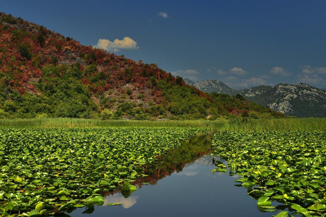
Skadar Lake is not only the largest in Montenegro but also throughout the Balkan Peninsula. This karst lake lies in the border area between Montenegro and Albania, with the Montenegrin part being larger than the Albanian. The Montenegrin section of Skadar Lake, along with its surroundings, was declared a national park in 1983.
Skadar Lake is a true natural wonder. The huge freshwater lake is surrounded by dramatic karst mountains. Its mirror-like waters reflect the rocky shores, and the wetlands are home to numerous wild animals and birds.
There are traditional fishing villages, monasteries on islands, and untouched beaches here. The national park features nine walking trails, five cycling paths, and two mountain bike routes.
Contact Information:
42.20716062146656, 19.261694287934194The Village of Njeguši
Njeguši is a village in southern Montenegro, located at an altitude of 910 meters above sea level. It is situated on the slopes of Mount Lovćen, within the territory of the eponymous national park.
The village is known as the birthplace of the Petrović dynasty (the Njegoš family), who ruled Montenegro from 1696 to 1918. Its rich history, traditional national cuisine, and the hospitality of its residents have contributed to the popularity of this place as a tourist destination.
The small mountain village of Njeguši is notable for its well-preserved ancient traditional architecture. You can visit the house of the Njegoš family, which exhibits historical artifacts. The villagers produce the famous Njeguši smoked cheeses and hams that you must try.
Contact Information:
42.43016620770765, 18.826438375306637Old Town
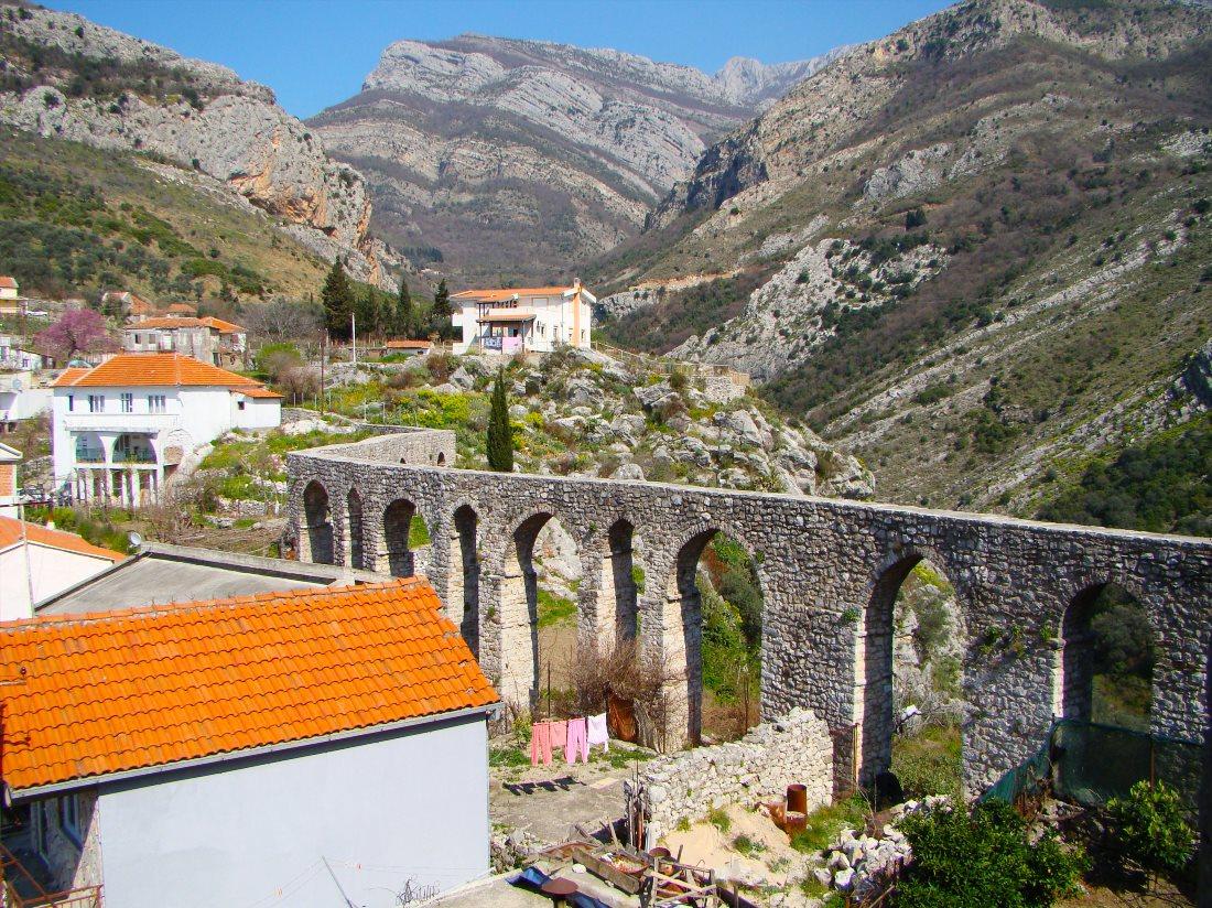
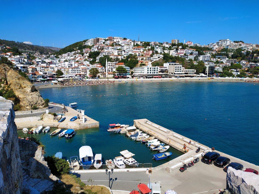
Old Town Bar is located on Mount Lonsha, at the foot of Mount Rumija. The first mention of this settlement dates back to the 6th century. Throughout history, this city became a subject of the Byzantine Empire, a medieval Serbian state, was under the rule of the Venetian Republic and the Ottoman Empire, and since 1878 has been part of Montenegro. The city was heavily damaged first by explosions in 1878 and then by the earthquake in 1979.
On the coast, a new town called Novi Bar was built, while many buildings in Old Bar, located four kilometers from the sea, survive today only as ruins.
Here, you can find ruins of the 11th-century cathedral, two churches, 11th-century city walls and an aqueduct that supplied the city with water, a well-preserved 17th-century mosque with a minaret, and other partially destroyed historical structures. In total, there are 240 structures of various purposes here.
Contact Information:
42.09309357442491, 19.133403950796687Žabljak
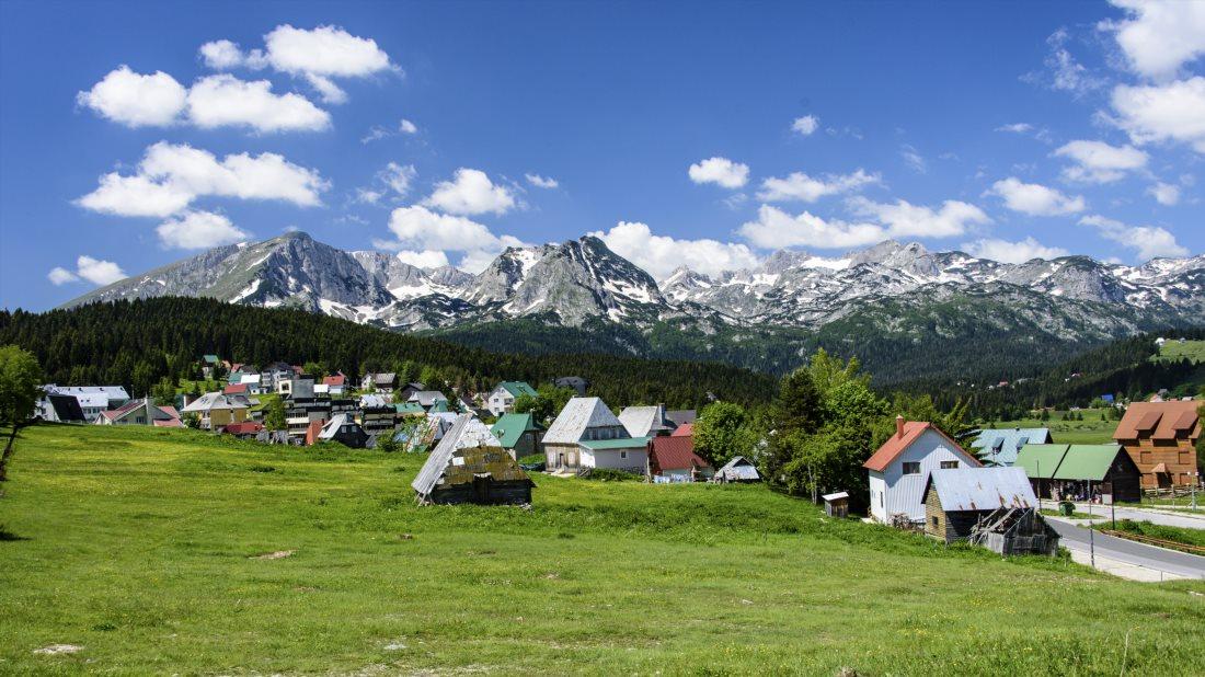
Žabljak is a small town in northern Montenegro, located in the center of the Durmitor mountain region, at an altitude of 1456 meters. It is considered the highest town in the Balkans. The main natural attractions of this area are 18 glacial lakes and numerous mountain peaks.
The entire territory of Durmitor is protected as a national park, providing excellent opportunities for both winter sports and summer tourism.
The town of Žabljak is the center of mountain tourism in Montenegro. The snow cover lasts here for 120 days a year, attracting snowboarding and skiing enthusiasts. Surrounding the town are trails for hiking. There are facilities for climbing and white-water rafting. The low hills are also great for mountain biking.
Contact Information:
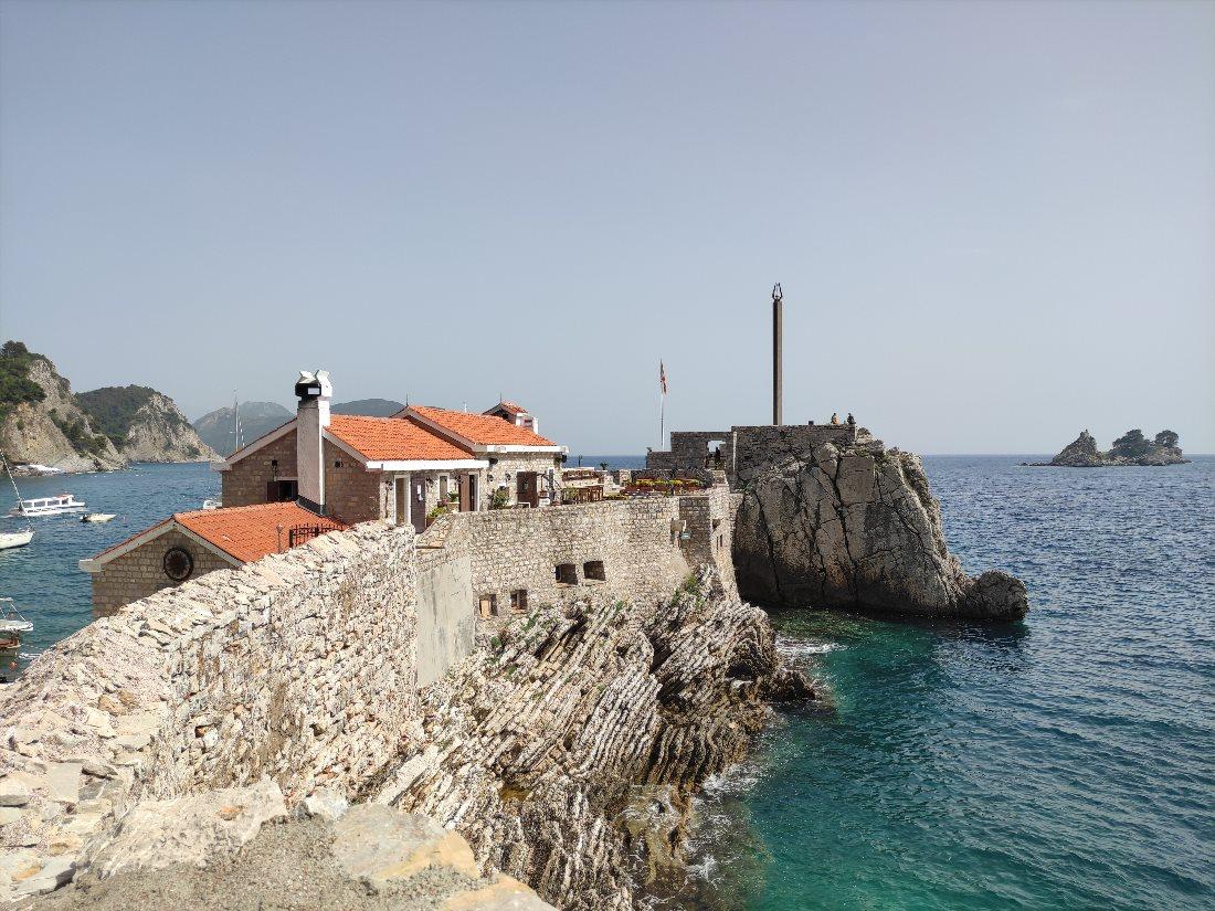
43.15416015014052, 19.122889656462046Fort Rose
Once in the western part of the Lustica Peninsula, there was a military base. Strong land fortifications housed naval forces here. The fort is located in the municipality of Herceg Novi, near the settlement of Rose.
The structures that have survived to this day were built in the late 19th century. In the 1930s, they were fortified and then used during World War II and afterward - until the end of the 1980s.
Today, all barracks, docks, gun platforms, underground catacombs, and other parts of the fortress are abandoned. The fortress walls were built from stone blocks with metal reinforcement designed to withstand direct hits from artillery shells. Because of this construction quality, the walls have remained fairly well-preserved to this day.
The remnants of fortifications, both above ground and underground, attract visitors to Fort Rose who are interested in the history and military architecture of recent times.
Ostrog Monastery
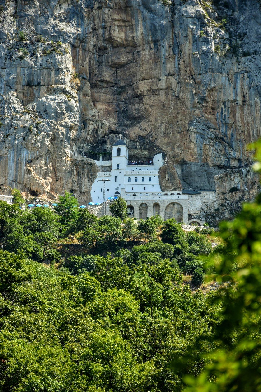
This monastery was founded by Metropolitan Basil in the 17th century. Its modern appearance was established between 1923 and 1926 after a fire destroyed many of its structures. From ancient structures, two cave churches remain, which are key parts of the complex.
In the upper monastery are the Church of the Meeting and the Church of the Holy Cross. In the center of the lower monastery stands the Church of the Holy Trinity, built in 1824, along with part of the monks' residences and dormitories for pilgrims.
The working Ostrog Monastery is the most popular pilgrimage site in Montenegro and the country's largest religious center. The upper church, dedicated to the Holy Cross, is built into a rocky cave. This white temple, visible from afar, is located at an altitude of 900 meters inside a vertical cliff.
It is difficult to imagine how it was constructed, which is why the upper monastery is often called "the miracle of Saint Basil." The monastery houses a shrine containing the relics of Saint Basil of Ostrog, which are believed to have miraculous properties.
Cetinje Monastery
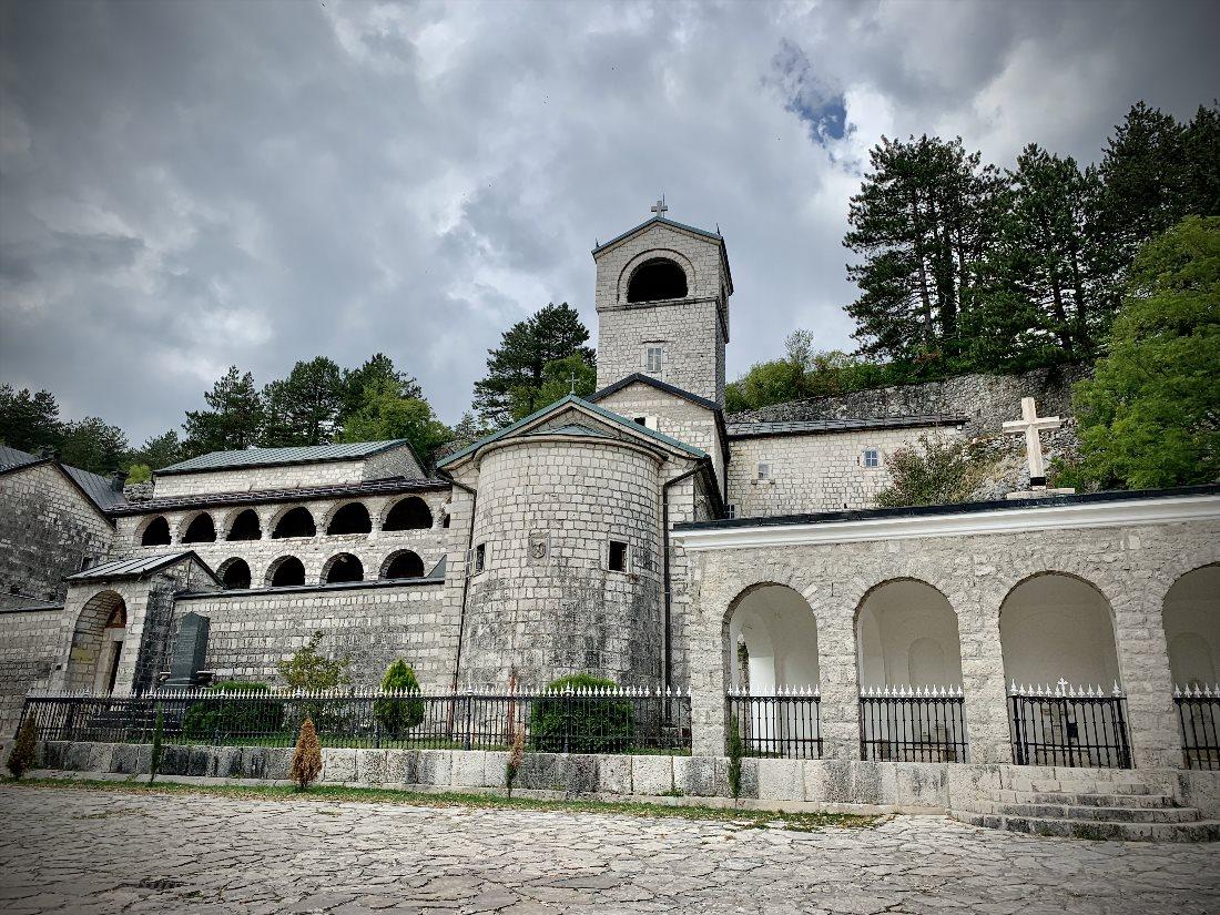
This Serbian Orthodox monastery is located in the town of Cetinje (the former royal capital of Montenegro) and serves as the residence of the Montenegrin metropolis. It was founded around 1484 and has been destroyed and restored several times throughout its history.
The monastery took on its modern appearance after restoration in 1927. The architectural style of the monastery complex reflects ancient Byzantine influences.
Valuable relics are kept in the monastery: the remains of Saint Peter of Cetinje and John the Baptist, pieces of the Life-Giving Cross, a list of the Filermian Mother of God icon, the crown of Serbian King Stefan Uroš III Dečanski, and more.
The monastery's treasury is open to tour groups. Here, you can see robes inlaid with precious stones, ancient icons, handwritten books, and a copy of the first book printed in the Serbian language.
Contact Information:
42.387832522591886, 18.921676368369173Moraca Monastery
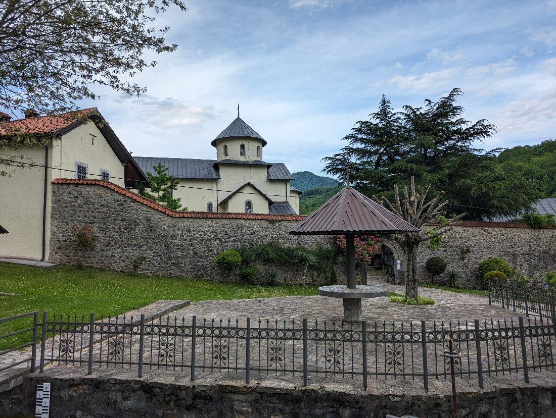
Founded in 1252, Moraca Monastery is one of the most important Orthodox monasteries in Montenegro and one of the most renowned medieval monuments in the country. The monastery, built of dense yellow-gray limestone, is located 46 kilometers from Podgorica in the picturesque valley of the Moraca River.
Within the monastery grounds are a large church dedicated to the Assumption of the Virgin Mary, a small church dedicated to Saint Nicholas, and buildings with monk cells. In addition to the church architecture, the frescoes adorning the temples are of particular interest. The oldest of them, depicting the life of the prophet Elijah, dates back to the 13th century.
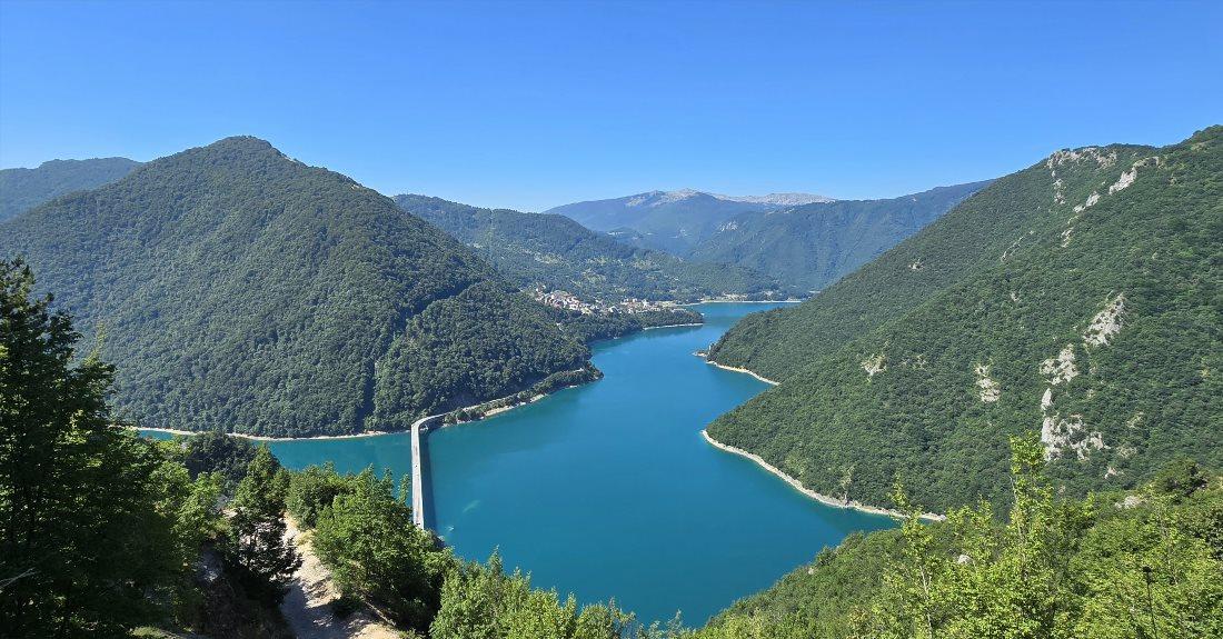
Piva Lake
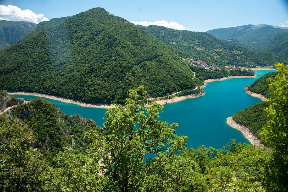
In 1975, the torrential flow of the Piva River was blocked by the dam of the Mratinje hydroelectric power station. This dam, rising 220 meters high, is one of the tallest in Europe. After its construction, Piva Lake was formed, making it the second largest in Montenegro.
At the bottom of the lake now lies the old town of Plužine. Before the dam's construction, the 16th-century Piva Monastery was located there but was dismantled and relocated stone by stone to the village of Goranak before flooding.
This artificial lake blends harmoniously into the picturesque landscape of the area. It resembles a wide river meandering between sheer cliffs and wooded mountains.
Piva Lake is considered one of the most beautiful lakes in Montenegro, and the water has a rich turquoise hue. Here, visitors can swim, fish, or just enjoy the beautiful nature. On the lake's shore, there is a cozy restaurant that serves local trout.
Contact Information:
43.1638669505475, 18.86248462710448Virpazar
Virpazar is a village in the municipality of Bar. It is located on the banks of the Crmnica River, which flows into the nearby Skadar Lake. Not long ago, Virpazar was a fishing village, but today it is turning into a tourist center on Skadar Lake.
On the hill above the settlement lie the ruins of the 15th-century Turkish fortress Besac, which were restored in 2013. Several bridges, two monasteries, and the Church of St. Athanasius are also present in the vicinity.
Virpazar serves as the primary "gateway" to Skadar Lake National Park. Daily, dozens of boats depart from here, taking tourists on water excursions across the lake's surface. In the souvenir shops of Virpazar, in addition to traditional magnets and mugs, interesting crafts by Montenegrin artisans can be purchased. Since 1997, the village has hosted the Wine and Anchovy Festival.
Contact Information:
42.24062255547366, 19.08814421610814The town of Prčanj
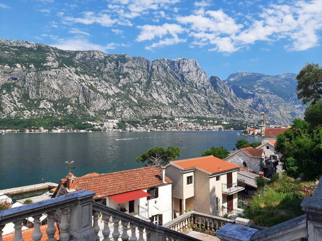
This small town is located along the Bay of Kotor, at the foot of the Vrmac mountain range. Throughout its history, it has been one of the most important maritime centers of southern Adriatic.
The town flourished in the 17th and 18th centuries, which is reflected in its architecture. Along the waterfront, a series of stone villas with beautiful facades create a medieval atmosphere.
The most impressive monument of Prčanj and the architectural hallmark of the town is the Church of the Nativity of the Blessed Virgin Mary. This massive cathedral, whose construction took 120 years (from 1789 to 1909), seems disproportionately large for such a small town.
The church contains a rich collection of icons, silverware, textiles, paintings, and sculptures.
Contact Information:
42.454032627344354, 18.74543298569902